
Instructions to candidates.
- Candidates should check the question paper has two sections A Question 1 to 5 and B Question 6 to 10.
- Answer question 6 and any other 2 questions in section B.
SECTION A: (25 marks)
Answer ALL questions in this section.
-
- Give three reasons why it is important to study Geography. (3 marks)
- State two factors that may influence occurrence of minerals. (2 marks)
-
- List two problems facing dairy farming in Kenya. (2 marks)
- State three factors that have encouraged dairy farming in Denmark. (3 marks)
-
- State three differences between natural forests and manmade forests. (3 marks)
- Name any four industries associated with forestry. (2 marks)
- Use the sketch map of Lake Victoria below to answer question (a)
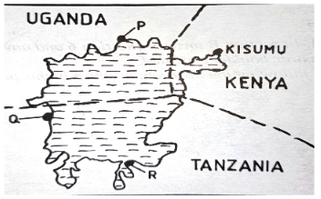
- Name the lake ports marked P, Q and R. (3 marks)
- Outline two advantages of using containers while handling goods at the port of Kisumu. (2 marks)
-
- Apart from water and air pollution, name two other types of pollution. (2 marks)
- Identify three ways through which water is polluted. (3 marks)
SECTION B. (75 marks)
Answer question 6 and ANY OTHER TWO questions.
- The table below shows the percentage of exports of country Y by Commodity.
COMMODITY %. Tea 47.3 Horticulture 21.6 Coffee 18.1 Beef products 13 - Draw a divided rectangle with a length of 10 cm to represent the above data. (7 marks)
- Give five characteristics of Horticultural Farming. (5 marks)
- Explain four factors that favour beef farming in Argentina. (8 marks)
- Explain three disadvantages of Plantation Farming. (6 marks)
-
-
- Apart from draining swamps give two other methods through which land has been reclaimed in Kenya. (2 marks)
- Give two methods that are used to reclaim swamps in Kenya. (2 marks)
-
- Name two rivers that supply water to the Mwea Tebere Irrigation scheme.(2 marks)
- Explain how the following factors influenced the establishment of the Mwea Tebere Irrigation scheme.
- Topography. (2 marks)
- Soils. (2 marks)
- Population Density. (2 marks)
- Government Policy (2 marks)
-
- Name three areas which make up the Zuider Zee reclamation project in the Netherlands. (3 marks)
- Give four differences between Land Reclamation in Kenya and the Netherlands. (8 marks
-
-
-
- Define the term energy. (1 mark)
- Distinguish between renewable and non-renewable sources of energy. (2 marks)
- Give three renewable sources of energy. (3 marks)
- Explain three ways in which Kenya has benefited from the development of hydro- electric power station. (6 marks)
- Use the sketch map of the seven folk’s scheme in Kenya below to answer the questions that follow.
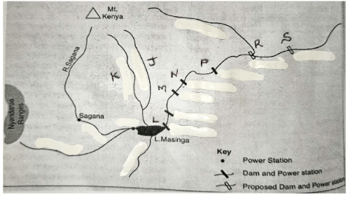
- Name the river marked J and K. (2 marks)
- Identify the dams marked L, M, N and P. (4 marks)
- Name the proposed hydroelectric power stations labeled R and S. (2 marks)
-
- Give two reasons why geothermal power has not been fully exploited in Kenya. (2 marks)
- State three causes of Energy Crisis in the world. (3 marks)
-
-
- Distinguish between Industry and Industrial Inertia. (2 marks)
- Use the map below to answer the questions that follow.
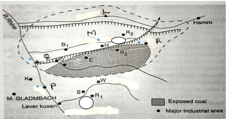
- Name the towns P, Q and R. (3 marks)
- Name rivers marked L and M. (2 marks)
-
- Apart from Iron and Steel Industries name three industries in the Ruhr Industrial region. (3 marks)
- State five reasons why the use of coal as a source of energy in the Ruhr region declined. (5 marks)
-
- State two significance of Car and Electronic Industries in Japan. (2 marks)
- Explain three factors which have favoured the development of car manufacturing industry in Japan. (6 marks)
- Name two towns in Kenya where Motor Vehicle Assembling Plants are located. (2 marks)
-
-
- Differentiate between Internal and Regional trade. (2 marks)
- List three major exports from Kenya to European countries. (3 marks)
- Give four reasons why the southern African development cooperation (SADC) was formed. (4 marks)
- Explain four problems facing trade in Kenya. (8 marks)
- Explain how the future of International trade in Kenya can be improved. (8 marks)
-
MARKING SCHEME
SECTION A.
Answer all questions in this section.
-
- Give three reasons why it is important to study Geography. (3mks)
- Geography provides knowledge about the immediate and the wider environment/makes us understand the earth on which we live.
- Creates awareness about the country and the rest of the world/promotes international understanding and cooperation. (Interdependence.)
- Promotes awareness on sustainable use of resources.
- Promotes development of skills and critical thinking.
- Prepares one for career opportunities.
- Promotes international consciousness through the study of geography of other areas.
- Teaches us how to manage time properly by drawing time schedule.
- Contributes to economic development especially on location of projects where the area has to be studied and surveyed.
- Promotes the understanding of the origin of the earth, the solar system and the internal structure of the earth.
- Assists in the achievement of national goals of education which includes unity, economic development and cultural fusion.
- Helps the learners to acquire scientific research skills such as observing, reading, recording, analyzing, presenting and interpreting statistical data, maps, charts, photographs and diagrams and making conclusions.
(Any 3×1= 3Mks)
- Geography provides knowledge about the immediate and the wider environment/makes us understand the earth on which we live.
- State two factors that may influence occurrence of minerals. (2mks)
- Veins and lodes which are cracks/joints in rocks.
- Beds and seams which are layers of the earth surface formed by deposition.
- Weathering which disintegrates rocks which in turn are leached by ground water.
- Alluvial deposits which are weathered material washed by running water.
- Give three reasons why it is important to study Geography. (3mks)
-
- List two problems facing dairy farming in Kenya. (2mks).
- Stiff competition from other farming activities.
- Expensive farm inputs.
- Impassable roads especially during rainy seasons.
- Prolonged periods of draught.
- Mismanagement of dairy cooperative societies.
- Importation of dairy products by unscrupulous businessmen.
-
State three factors that have encouraged dairy farming in Denmark. (3mks)
-
Availability of high nutritious fodder. - Well managed cooperative societies.
- Consolidation of small farm units.
- Invention of modern milking machines.
- Ready market both home and abroad.
- Availability of capital.
- Advanced technology.
-
- List two problems facing dairy farming in Kenya. (2mks).
-
- State three differences between natural forests and manmade forests. (3mks)
Natural Man-made 1 Trees are of mixed species. Are in pure stands/bands of single species. 2 Are indigenous. Are exotic. 3 Mature at different times. Exploit at the same time. 4 Difficult to exploit. Easy to exploit. 5 Are hardwoods. Are mainly softwoods. - Name any four industries associated with forestry. (2mks)
- Furniture making.
- Construction.
- Paper and pulp.
- Tanning.
- Wood carving.
- State three differences between natural forests and manmade forests. (3mks)
- Use the sketch map of Lake Victoria below to answer question (a)
- Name the lake ports marked P, Q and R. (3mks)
- P- Jinja
- Q- Bukoba.
- R-Mwanza.
- Outline two advantages of using containers while handling goods at the port of Kisumu. (2mks)
- They guard against destruction of goods.
- They make loading and offloading of goods easy and safe.
- They are even in shape hence occupy less space.
- They guard against theft of goods.
- Name the lake ports marked P, Q and R. (3mks)
-
- Apart from water and air pollution, name two other types of pollution. (2mks)
- Land pollution./soil/ground.
- Noise pollution/sound.
- Thermal pollution.
- Radiation.
- Identify three ways through which water is polluted. (3mks)
- Discharge of industrial waste/oil spillage/radioactive waste into water bodies.
- Disposal of domestic waste into water bodies.
- Discharge of agricultural chemicals into water bodies.
- Abuse of water bodies by human beings.
- Natural causes e.g. soil erosion and terrestrial gas.
- Apart from water and air pollution, name two other types of pollution. (2mks)
SECTION B.
- The table below shows the percentage of exports of country Y by Commodity..
COMMODITY %. Tea 47.3 Horticulture 21.6 Coffee 18.1 Beef products 13 - Draw a divided rectangle with a length of 10 cm to represent the above data. (7mks)
100% = 10 cm.
TEA.
43.3 X 10 = 4.7 cm.
100
HORTICULTURE CROPS.
21.6 X 10 = 2.2 cm.
100
COFFEE.
18.1 X 10 = 1.8 cm.
100
BEEF PRODUCTS.
13 X 10 = 1.3 cm.
100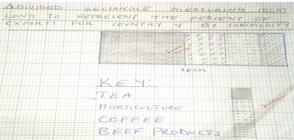
- Give five characteristics of horticultural farming. (5mks)
- It requires a lot of farm inputs e.g. fertilizers, pesticides and herbicides hence needs high capital outlay
- The farms are smaller in size except for the large scale flower farms in Naivasha
- Farms are located in areas with good and reliable transport infrastructure since horticultural products are highly perishable
- Advanced scientific techniques of crop production are applied to ensure high yields
(Any 5×1= 5Mks)
- Explain four factors that favour beef farming in Argentina. (8mks)
- Moderate and well-distributed rainfall throughout the year of about 1000mm favours growth of pastures and regular supply of water for cattle.
- The moderate temperatures of 10°C – 24°C favour the growth of grass all year round.
- Fertile soils washed from the foothills of Andes by rivers are deposited in the low-lying areas, giving rise to good natural pastures.
- Extensive and rolling grasslands (pampas) at the foot of Andes Mountains provides good sites for natural grazing and pasture.
- Availability of highly nutritious temperate grass.
- Well-established railway network eases accessibility.
- Adequate capital to mechanize farm operations and install refrigeration facilities.
- Highly organized cattle ranches, which are fairly mechanized.
- Introduction of exotic breeds (short horn, Hereford) ensures high quality meat.
- Replacement of natural pasture with alfalfa, which is highly nutritious and matures faster.
- Availability of market locally in the European countries.
(Any 4 x 2= 8Mks)
- Explain three disadvantages of plantation farming. (6mks.)
- Concentration on cash crop has resulted in food shortages due to neglect of food crops.
- Monoculture has led to soil exhaustion.
- Plantation farming is capital intensive.
- If the world market prices fall huge losses are experienced. /High loses can also be experienced in the event of disease outbreak or occurrence of natural calamities.
- Draw a divided rectangle with a length of 10 cm to represent the above data. (7mks)
-
-
- Apart from draining swamps give two other methods through which land has been reclaimed in Kenya.(2mks)
- Irrigation.
- Tsetse fly control.
- Planting of trees/Afforestation.
- Flood control.
- Give two methods that are used to reclaim swamps in Kenya (2mks)
- Constructing drainage pipes.
- Digging open ditches.
- Pumping out the water.
- Apart from draining swamps give two other methods through which land has been reclaimed in Kenya.(2mks)
-
- Name two rivers that supply water to the Mwea Tebere Irrigation scheme. (2mks)
- Thiba River.
- Nyamindi River.
- Murubara.
- Explain how the following factors influenced the establishment of the Mwea Tebere Irrigation scheme.
- Topography. (2mks)
- The gentle sloping land makes it possible for water to flow by gravity into/out of the irrigated fields.
- The gently sloping land allows for mechanization which allows large areas to be put under cultivation.
- Soils. (2mks)
- Presence of black cotton soils which is suitable for cultivation of rice/which retains water for a long time.
- Population Density. (2mks)
- The area was originally sparsely populated which enabled large areas to be put under cultivation/very few people were displaced thus it was cheap to start the scheme.
- Government Policy (2mks)
- There was need to keep political detainees busy/this made the colonial government set up scheme the scheme at Mwea where there was a large detention camp.
- Topography. (2mks)
- Name two rivers that supply water to the Mwea Tebere Irrigation scheme. (2mks)
-
- Name three areas which make up the Zuider Zee reclamation project in the (3mks)
- Netherlands.
- Marker Waard
- South Flevoland
- East Flevoland.
- North Eastern polder.
- Weiringer Meer Polder
- Give four differences between Land Reclamation in Kenya and the Netherlands. (8mks)
(Any 4 X 2= 8Mks)KENYA NETHERLANDS 1 Area reclaimed is relatively small. The areas being reclaimed are large. 2 Mainly reclaimed from swamp and marginal areas. Reclaimed from the sea and swamps. 3 Methods used for draining water from marshy areas is digging of canals/ditches. Advanced methods/use of wind pumps to drain sea water from the polders. 4 Irrigation is used as a mean of reclaiming dry areas. Irrigation is used to lower salinity of the soils in the reclaimed lands. 5 Methods of land reclamation are simple (digging canals/ditches to drain water from the land.) Methods used are highly advanced like reclaiming land from the sea/creation of polders. 6 Furrows/Ridges are used to control river
floods.Dykes protect the reclaimed+ land from
invasion by the sea.
- Name three areas which make up the Zuider Zee reclamation project in the (3mks)
-
-
- Define the term energy. (1mk)
- This is the power/fuel needed to run a machine or to assist humans in production.
- Distinguish between renewable and non-renewable sources of energy. (2mks)
- Renewable source of energy refers to energy sources that can be reproduced or regenerated e.g. hydro, solar, biogas etc. while non-renewable refers to sources of energy that cannot be reproduced or regenerated e.g. Petroleum, uranium and natural gas.
- Give three renewable sources of energy. (3mks)
- Hydro, tides, waves, wood/charcoal, Solar and Biogas
- Define the term energy. (1mk)
- Explain three ways in which Kenya has benefited from the development from the development of hydro-electric power station. (6mks).
- The dams have contributed to micro climates in the areas where they are located.
- Construction of dams has assisted in control of floods.
- The dam generates H.E.P which is supplied to various parts of the country
- The dam has led to the creation of water reservoirs, which provide water for irrigation
- Dam has led to the opening up of areas through road construction
- Water reservoirs encourage fishing
- Employment is offered to many Kenyans raising their standards of living.
- The dams are a tourist attraction and Masinga tourist lodge nearby provides recreational facilities.
(Any 3X 2= 6Mks)
- Use the sketch map of the seven folk’s scheme in Kenya below to answer the questions that follow.
- Name the river marked J and K. (2mks)
- K- Thiba
- J- Nyamindi
- Identify the dams marked L, M, N and P. (4mks)
- L- Masinga.
- M- Gitaru
- N- Kindaruma.
- P- Kiambere.
- Name the proposed hydroelectric power stations labeled R and S. (2mks)
- R- Mutonga
- S- Grand Falls.
- Name the river marked J and K. (2mks)
-
- Give two reasons why geothermal power has not been fully exploited in Kenya. (2mks)
- Inadequate skilled manpower to harness geothermal power
- Danger of land subsidence as tectonic fluids are withdrawn.
- Inadequate capital to develop more plants in Ol Karia and other potential areas.
- Low level of technology in exploitation of geothermal power.
- Potential areas are scattered and located in remote, sparsely populated areas which are far from the market.(Any 2 x 1= 2Mks)
- State three causes of energy crisis in the world. (3mks)
- Escalation in oil prices triggered by sharp rise in demand
- Uncertainties in oil supply/rapid depletion of oil reserves
- Control of oil reserves by a few oil producing countries
- Unequal pattern of crude oil distribution in the world
- Artificial shortages created by USA and Russia decide to conserve their resources and depend on world market for their requirements
- Economic and political embargoes (wars)
- Misuse of energy sources
(Any 3 x1= 3Mks)
- Give two reasons why geothermal power has not been fully exploited in Kenya. (2mks)
-
- Distinguish between Industry and Industrial Inertia. (2mks)
- Industry is an organized economic activity concerned with the processing and manufacturing of raw materials into useful products/production of goods and services for sale/consumption while Industrial Inertia is a situation in which an industry continues to operate in an area even after the factors that attracted it to the area are no longer existing/present
- Use the map below to answer the questions that follow.
- Name the towns P, Q and R. (3mks)
- P- Düsseldorf.
- Q- Duisburg.
- R- Dortmund.
- Name rivers marked L and M (2mks)
- L- R. Lippe
- M- R. Emscher.
- Name the towns P, Q and R. (3mks)
-
- Apart from iron and steel industries name three industries in the Ruhr Industrial region. (3mks)
- Engineering.
- Textile industries.
- Oil refining.
- Electronics.
- Food processing.
- Cutlery and surgical instruments.
- Chemical/petro-chemical industries.
(Any 3 x 1= 3Mks)
- State five reasons why the use of coal as a source of energy in the Ruhr region declined. (5mks)
- There has been an increase in the use of alternative sources of energy like H.E.P natural gas and oil.
- The cost of extracting coal has risen because of the deepening of mines.
- Mining of coal has led to land degradation.
- Coal produces a lot of smoke hence a pollutant to the environment.
- Other sources of energy like H.E.P are easy to transport than coal which is bulky.
- Coal has low calorific value compared to other sources of energy.
(Any 5 x 1= 5Mks)
- Apart from iron and steel industries name three industries in the Ruhr Industrial region. (3mks)
-
- State two significance of car and electronic industries in Japan. (2mks)
- Foreign exchange earnings.
- Increased job opportunities.
- Growth of town’s e.g Yokohama, Osaka, Kyoto, Akashi, Okayami.
- Improved transport network.
- Establishment of training Industries.
(Any 2 X 1= 2Mks)
- Foreign exchange earnings.
- Explain the three factors which have favoured the development of car manufacturing industry in Japan. (6mks.)
- Power: - Japan lacks petroleum/coal/natural gas but being mountainous with many rivers that has led to the development of HEP projects that provide energy for industrial use. Nuclear energy is also available
- Advanced technology/automation/all plants are computerized has led to high/efficient and increased car/electronics production.
- Geographical location: - Japan is accessible to all parts of the world via the sea which makes the importation of raw materials and exportation of cars/electronics possible.
- Capital: - profits realized from other industries e.g. ship building, fishing and tourism are invested in the development of car/electronics industries through purchase/importation of raw materials.
- Abundant water supply: - Japan is surrounded by the Pacific Ocean and many rivers/lakes within the islands that provide water for use in the iron and steel industry whose products are in turn used in car and electronics manufacture.
- Rugged landscape: - in Japan does not favour development of agriculture and has therefore concentrated on the development of manufacturing industries to enable earn capital for importation of food.
- Skilled man power: - Japanese labor is skilled and highly dedicated to the development ventures leading to quantitative and qualitative production of automobiles and electronics
- Affordable products: - most of the Japanese. Automobiles and electronics are relatively cheap and of better quality. They are sold cheaper compared to the same from Europe. They are also durable, cheaper to maintain and readily available. They are therefore on very high demand all over the world.
(Any 3 x 2= 6Mks)
- Name two towns in Kenya where motor vehicle assembling plants are located. (2mks)
- Nairobi
- Thika
- Mombasa.
- Nairobi
- State two significance of car and electronic industries in Japan. (2mks)
- Distinguish between Industry and Industrial Inertia. (2mks)
-
-
- Differentiate between internal and regional trade. (2mks)
- Internal trade Involves buying and selling of goods and services within a country while Regional trade is between countries that are found in the same geographical region.
- List three major exports from Kenya to European countries. (3mks)
- Coffee,
- Tea,
- Fluorspar,
- Horticultural Products/Flower/Fruits/Vegetable
- Pyrethrum extract.
(Any 3 x 1= 3Mks)
- Differentiate between internal and regional trade. (2mks)
- Give four reasons why the southern African development cooperation (SADC) was formed. (4mks)
- To promote and co-ordinate regional integration
- To foster international cooperation
- To facilitate trade and economic liberalization.
- Create a large market for goods and services to be bought and/or sold
- They have helped to create harmony and cooperation among the member states
- Reduction of tariffs making the goods cheaper in the region
Expanded markets (Any 4 X 1= 4Mks)
- Explain four problems facing trade in Kenya. (8mks)
- Nature of imports and exports
- Kenya mainly exports agricultural and mineral commodities of low value. It also imports machinery and finished products of higher values resulting to an adverse balance of trade hence trade deficit
- Scarcity of goods
- Some goods required by consumers in given places may be lacking may be due to adverse weather conditions e.g. prolonged drought or exhaustion of mines. This makes them to be expensive and unavailable
- Poor infrastructure
- Most parts of the country have poor transport network making it difficult to transport goods to various markets.
This makes the transport expensive leading to marginal profits
- Most parts of the country have poor transport network making it difficult to transport goods to various markets.
- High charges/tariffs
- The charges levied by the government in terms of taxes and councils inform of levies to conduct businesses are very high making the traders to earn little profits and discourages importation
- Inadequate Capital
- Most traders operate in small scale and have to rely on banks and micro-finance institutions to expand their trading activities.
The interests charged by the banks are very high limiting the profits.
- Most traders operate in small scale and have to rely on banks and micro-finance institutions to expand their trading activities.
- Insecurity
- In some areas traders may be attacked by thugs and lose their goods/proceeds. They therefore have to invest in heavy and expensive security system that eats into their profits.
- Trade restrictions/barriers
- The government may impose restrictions on goods to be imported or exported. Other countries/trading blocs may also impose bans on importation of some commodities from Kenya
- Smuggling
- Some unscrupulous traders may import goods into the country without following the correct procedures. Such goods evade taxes thus denying the country revenue and also impose unfair
competition from traders who have imported correctly
- Some unscrupulous traders may import goods into the country without following the correct procedures. Such goods evade taxes thus denying the country revenue and also impose unfair
- Dumping of goods
- This refers to the selling of goods in an external market at a price cheaper than that charged in the exporting country. It may lead to a decline in market for local goods due to the cheap imports.
(Any 4 X 2= 8Mks)
- This refers to the selling of goods in an external market at a price cheaper than that charged in the exporting country. It may lead to a decline in market for local goods due to the cheap imports.
- Nature of imports and exports
- Explain how the future of International trade in Kenya can be improved. (8mks)
- Setting up industries in the neighboring countries/within COMESA/EAC regions
- Improvement of infrastructure connecting/linking neighboring countries to facilitate easy movement of goods and people along the borders.
- Expansion of other markets e.g. in Europe and Middle East.
- Holding trade exhibitions/fares in partner countries to enlighten Kenya’s trade potential thus increasing trade.
- Use of conditions of AGOA e.g. various countries are allocated quotas to export textile to overseas especially USA.
- Reduction of import duties through EAC agreeing on a common customs unions
- Establishment of import substitution industries to reduce importation of commodities.
- Development of alternative sources of energy (H.E.P, solar, biogas) to reduce expenditure on oil importation.
- Encouraging local assembling of machines since importation of parts is cheaper.
- Finding new markets for exports to avoid dependence on a few trading partners.
- Diversification of exports.
- Encouraging use of appropriate/local technology that does not require heavy machinery.
- Encouraging exportation of locally manufacturing goods.
- Increasing invisible trade e.g. shipping, tourism, insurance.
- Restricting the importation of luxury items through higher taxation.
- Encouraging the production of high quality/manufactured goods for export in order to earn higher income.
(Any 4 x 2= 8Mks)
-
Join our whatsapp group for latest updates
Tap Here to Download for 50/-
Get on WhatsApp for 50/-
Download Geography Paper 2 Questions and Answers - Bunamfan Post Mock 2021 Exams.
Tap Here to Download for 50/-
Get on WhatsApp for 50/-
Why download?
- ✔ To read offline at any time.
- ✔ To Print at your convenience
- ✔ Share Easily with Friends / Students