
INSTRUCTIONS TO CANDIDATE
- This paper has two sections A and B.
- Answer all the questions in section A.
- Answer questions 6 and any other from section B.
- Answer must be written in the answer booklet provided.
- This paper consists of 4 printed pages.
- Candidates must check the question paper to certain that all pages are printed as indicated and no questions are missing
SECTION A
ANSWER ALL THE QUESTIONS IN THIS SECTION
- The diagram below the structure of the earth.
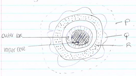
- Name the parts marked P, Q and R. (3mks)
- Name the minerals that make up SIAL (2mks)
-
- State the plate tectonic theory (2mks)
- List THREE types of boundaries associated with plate tectonic movement. (3mks)
-
- what is a Stevenson screen (2mks)
- State THREE essential features of a Stevenson screen (3mks)
-
- Differentiate between weathering and mass wasting (2mks)
- State THREE effects of soil creep on the earth surface (3mks)
-
- The diagram below shows some features found in Karst Scenery.
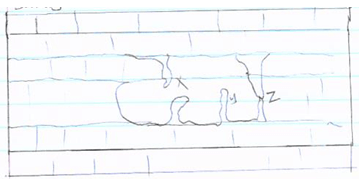
Name the features marked X, Y and Z (3mks) - State TWO ways in which lakes influence the natural environment (2mks)
- The diagram below shows some features found in Karst Scenery.
SECTION B
ANSWER QUESTION 6 AND ANY OTHER TWO QUESTIONS FROM THIS SECTION
- Study the map of MIGWANI (1:50,000) sheet 151/1 provided and answer the following questions
-
- Give the latitudinal extent of the area covered by the map (2mks)
- What is the magnetic variation of the map (1mk?)
- Convert the ratio scale of the map into statements scale (2mks)
- Citing evidence from the map give THREE economic activities carried out in the area covered by the map. (6mks)
- Explain how relief has influenced the distribution of settlement in the area covered by the map (4mks)
-
- Using a vertical scale of 1cm to represent 100metres, draw a cross-section along the line marked J-K (4mks)
- On it mark and label the following
- Footpath (1mk)
- Road (1mk)
- Water pipeline (1mk)
- steep slope (1mk)
- Calculate the vertical exaggeration of the cross-section (2mks)
-
-
-
- what is a river divide (1mk)
- Describe THREE ways by which a river transport its load (6mks)
- Describe the characteristics of a river on its old stage (7mks)
- Describe each of the following drainage system and patterns
- Superimposed drainage system (3mks)
- Centripetal drainage pattern (2mks)
- You have planned to carry out a field study of a river in its youthful stage.
- State TWO ways in which you would prepare for the study (2mks)
- Name TWO features you are likely to study (2mks)
- List TWO problems you are likely to experience during the study (2mks)
-
-
- List FOUR processes through which coasts are eroded (4mks)
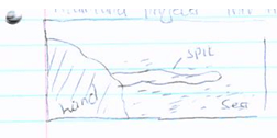
- Using well-labeled diagram, explain how each of the following features is formed
- A spit (4mks)
- A blow hole (2mks)
- A toll (5mks)
- Some students carried out a field study on the coastal features found along the coast.
- List THREE features formed as a result of coastal emergence that they are likely to have studied (3mks)
- State THREE methods that student may have used to record their data (3mks)
- Describe TWO ways in which features resulting from coastal emergence are of significance to Kenya (2mks)
-
-
- Distinguish between Orogenic And Epeirogenic earth movement(2mks)
- Describe how convectional currents cause earth movements (5mks)
- Explain THREE factors that determine the type of features resulting from earth movements (6mks)
- Describe the types of boundaries created as a result of earth movement (6mks)
- A form two class conducted a field study in an area that had undergone earth movement
- Give TWO examples of transform faults they would have observed (2mks)
- Name TWO oceanic plate they would have observed (2mks)
- Give the main reason why the interview method was not the appropriate method collecting the data (2mks)
-
-
-
- Apart from fold mountains name THREE other features resulting from folding (3mks)
- Identify FOUR examples of Fold Mountains outside Africa (4mks)
- Explain TWO major factors that influence folding (4mks)
- Describe the formation of Fold Mountains using the contraction theory (6mks)
- Explain the effects of folding on the following Agriculture(2mks) tourism (2mks) mining (2mks Transport (2mks)
-

MARKING SCHEME
-
- p-atmosphere
Q-crust/lithosphere
R-mantle/Asthenosphere - silica
- Aluminium
- p-atmosphere
-
- plate tectonic theory suggests that the continental crust is made up of rigid blocks that float on the mantle
- Extensional boundaries/constructive boundaries
Compression boundaries/destructive boundaries
Conservative boundaries /transform boundaries
-
- It is a wooden weather box where some weather measuring instruments are kept
-
- It should be painted white to reflect direct sun rays
- It should be raised 121cm from the ground to prevent contact with direct radiation from the earth surface
- It should have louvered window to allow free flow of air
- Roof made of double boards to prevent sun’s heat reaching the screen
-
- Weathering is the disintegration of rocks on the earth’s surface in site while mass wasting is the down slope movement of weathered material under the influence of gravity
- Effects of soil creep on the earth surface
- It can push fence posts and telegraph poles from their original positions so they appear inclined
- Stone walls built across the slope can be destroyed by the creeping soil
- Soil creep results in the accumulation of soil particles at the base of the slope
- Soil creep can also interfere with infrastructure such as road and railways
- When fine soil particles move downhill the upper slope are left bare and exposed
-
- x-stalactite
Y-stalagmite
Z-limestone pillar /pillar/limestone column - are reservoirs in the water cycle
- support bio-diversity/support flora fauna
- Modify local weather and climate
- Regulation of river flow/controlling flooding
- x-stalactite
MAP WORK
-
-
- Latitudinal extent 10 051 to 10 151s (2mks)
- Magnetic variation-20231 (2mks)
- Ration scale into a statement scale
1:50,000
1cm rep 50,000cm
1km=100,000
1cmrep 0.5km
- Economic activity Evidence
Trading presence of shops
Quarrying presence of quary
Transport and communication presence of road
Forestry/lumbering presence of mutito forest - Distribution of settlement
- The central part of the area is sparsely settled because it is a steep slope
- The south western part is sparsely populated because it is a steep slope
- The north western part is more settled because it is a gentle slope
- The eastern part is also sparsely settled because of scrub vegetation
A CROSS-SECTION ALONG THE LINE MARKED J-K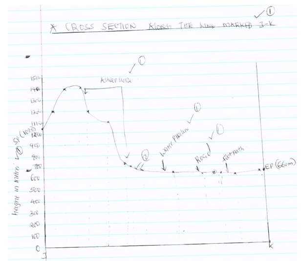
-
-
-
- A river is a high ground that separates two or more river basins
- Traction process/rolling/sliding-The large and heavy particles of the river .Load are rolled/dragged along the river bed
- Saltation process –particles that are not too heavy but cannot remain suspended in water are momentarily lifted by the water turbulence and at times dropped onto the river bed
- Solution –soluble minerals are dissolved in the river water and carried away in solution
- Suspension-light particles of the load are carried and maintained within the turbulence of flowing water
- Characteristics of a river in its old stage
- The widening of the valley through latent erosion creater an extensive area where the river deposits its load, the gradient of the plain is low
- The is speed of the flow is low the gradient of the plain is low
- Due to the slow speed and the high deposition, the river forms pronounced meanders
- Due to the slow speed, the main work of the river is deposition
- Meanders become more pronounced with narrow neck which are eventually blocked by meanders ox-bow Lake-Increased deposition along the channel raises the river bed may eventually form small Islands /braided channel/river braids
- Deposition along the banks of the river channel leads to formation of leeves
- The reduced speed and increased deposition blocks the river mouth forcing the rivers to form distributances/delta (any 7points)
- Description of drainage pattern/systems
- Superimposed system
- The drainage system develops on a rock structure that overlay a totally different one
- The river valley cuts through the surface rocks layer onto the underlying rocks
- Gradually the surface rocks are removed and the underlying rocks now become exposed
- The superimposed drainage system bears no relationship to the existing rocks structure /discordant with the rods structure
Centripetal pattern - The pattern develops in an area with a central basin.
- Rivers drain into the depression from different directions
- Superimposed system
-
- You have planned to carry out a study of a river in its youthful stage preparation for the study
- Carry out reconnaissance survey
- Read fro reference books /seek permission from the authority
- Prepare a sketch map
- Formulate objectives from the study/hypothesis of the study
- Prepare relevant stationary
- Two features you are likely to study
- Interlocking spurs
- Gorges
- Waterfall, rapid, cataracts
- Potholes, plunge, Slope River, slope pools
- Two problems you are likely to experience during the study
- Steep slope
- Thick vegetation
- Poor communication/bad roads
- Hostile weather condition (to be specified)
- Wild animals crossing the valley
- You have planned to carry out a study of a river in its youthful stage preparation for the study
-
-
- four processes through which coast are eroded
- By hydraulic action
- Abrasion /corrosion
- Solution /corrosion
-
- Formation of spit
- It forms on shallow shore at a point where there is a change in the angle of the coastline
- Sand or shingle is deposited by long shore drift
- Deposition continue and materials accumulate sea ward
- With time an elongated features with one end attached to the mainland project into the sea and it’s called a spit (Text max 3, diagram 1=4mks
Formation of blow holes - Waves erosion acts on a line of weakness at the back part of the roof of a sea cave
- At the same time weathering especially by the solution acts on the line of weakness from the surface downwards
- Eventually a vertical shaft /hole which connects the surface to the cave below is formed and it’s called a blowhole
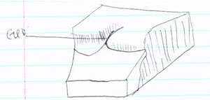
Formation of a toll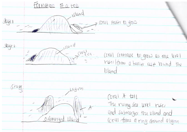
Diagram -2, text 3, total =5m
-
- Three features formed as a result of coastal emergence that they are likely to have studied
- Raised beaches
- Raised wave –cut platforms
- Raised coral/exposed coral rocks
- Cliff
- Mudflat
- Three methods the student may have used to their data
- Taking photographs
- Drawing sketches/maps/diagrams
- Tabulating /tallying
- Labeling samples
- Making notes/taking notes
- Two ways in which features resulting from coastal emergence are of significance of Kenya
- Some are tourist attraction
- Coral provides raw material for cement manufacturing
- Coral rocks are used as building materials
- They provide an environment for education /research activities
- Three features formed as a result of coastal emergence that they are likely to have studied
- four processes through which coast are eroded
-
-
- Orogenic are horizontal/internal earth movements while epeirogenic are vertical earth movements.
- Describe how convectional currents cause earth movement
- Convectional currents are found within the molten rocks of the mantle
- The currents cause the molten rock to circulate in a cyclical manner
- These current move from inside the mantle towards the surface of the mantle and then horizontally and finally vertically inwards
- As the currents move horizontally beneath the sima they exert a frictional pull on the crustal rocks causing them to move horizontally
- When these currents meet them beneath the crust they sink inwards causing the rocks directly above the convergence point to move vertically inwards
- This causes both horizontal and vertical movements in the earth’s crust
- Three factors that determine the type of features resulting from earths movements
- The nature of the rocks. Rocks that can easily break can lead to the formation of faulted features while rocks that are flexible will lead to the formation of folded features
- Age of rocks .Young rocks can easily bend and therefore will lead to the formation of folded features while old rocks will easily crack and will therefore lead to the formation of faulted features
- The intensity and scale of forces involved
- Describe the types of boundaries
- Extension boundaries is the type of boundary created when plates move away from one another
- Compression boundary is the type boundary created at the zone of convergence plate more towards one another
- Conservative boundary is the type of boundary created when plates move past each other along the transform fault.
-
- Give two examples of transform faults
- The great Glen fault in Scotland
- San Andreas fault in California
- Two oceanic plates they would observe
- Pacific plate
- Nazca
- Give the main reason why the interview method was not appropriate
- There could not have been people to interview
- Give two examples of transform faults
-
-
-
- Apart from Fold Mountains name three other features resulting from folding
- Ridges and valley landscape
- Rolling plains
- Intermontane basins
- Four examples of Fold Mountains outside Africa
- Andes
- Appalachian
- Rockies
- Alps
- Himalaya
- Apart from Fold Mountains name three other features resulting from folding
- Major factors that influence folding
- The nature of the rocks whether elastic or resistant to force
- The amount of force exerted on the rocks
Formation of Fold Mountains using the contraction theory - During the formation of the surface rocks cooled and contracted faster than those of the interior
- Since the interior was cooling at a slower rate the surface rocks started wrinkling in order to fit on the cooling and contracting rocks of the interior
- These wrinkles became Fold Mountains
-
EFFECTS OF FOLDING ON
Agriculture-windward side of Fold Mountain has rainfall that support the growth of crops
Tourism-folded features such as Fold Mountains attracts tourists who bring foreign exchange which is used to develop infrastructural facilities such as roads
Mining-during the process of folding and formation of features such as ridge and valley landscape some minerals are exposed and brought to the surface making exploitation easier
Transport-folded features like rolling plains and intermountain plateau and basins are barriers to transport and communication lines
Join our whatsapp group for latest updates
Tap Here to Download for 50/-
Get on WhatsApp for 50/-
Download Geography Paper 1 Questions and Answers - Mwakican Joint Pre Mock Examination 2021.
Tap Here to Download for 50/-
Get on WhatsApp for 50/-
Why download?
- ✔ To read offline at any time.
- ✔ To Print at your convenience
- ✔ Share Easily with Friends / Students