
INSTRUCTIONS TO STUDENTS
- This paper has two sections A and B
- Answer ALL the questions in section
- In section B answer questions 6 and any other two
SECTION A (25MARKS)
Answer all the questions in this section
-
- What is the relationship between Geography and Chemistry? (2marks)
- Give three reasons why the interior of the Earth is hot. (3marks)
-
- Distinguish between Vulcanicity and Volcanicity. (2marks)
- Give two characteristics of basic lava domes. (2marks).
-
- What is desertification? (2marks)
- State three negative effects of desertification. (3marks)
- The diagram below shows an upland area.
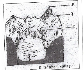
- Name the feature P, Q and R. (3 marks)
- How is a u-shaped valley formed? (3 marks)
-
- State three ways in which lakes are formed. (3 marks)
- Give two characteristics of lakes formed due to faulting. (2 marks)
SECTION B
Answer question 6 and any other TWO questions from this section
- Study the map of Busia (1:50,000) sheet 101/1 provided and answer the following questions.
-
- Give the latitudinal and longitudinal position of South East corner of the map (2marks)
- Give two methods that have been used to represent relief. (2marks)
-
- What is the length in Kilometres of the All-weather loose surface road (C526) from the road junction at Odiado to the road junction at Bumula. (2marks)
- What is the bearing of the road junction at Matayo from the air photo Principal(2 marks)
- Give three social services that are provided at Funyula. (3 marks)
- Describe the drainage of the area covered by the map. (6marks)
-
- Apart from trading, name two other economic activities in Busia area. (2marks)
- Citing evidence from the map, explain three factors that favour trading in the area covered by the map. (6marks)
-
-
-
- What is folding (2marks)
- Name one country where the following fold mountains are found.
- Andes (1mark)
- Atlas (1mark)
- The diagram below shows a types of fold.
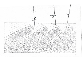
Name the features marked x, y and z ( 3marks) - With the aid of a labelled diagram, describe how an overthrust fold is formed.(6 marks)
- Explain four effects of fold mountains on climate (8marks)
- Form four students in your school are planning to study land forms through field work.
Give four reasons why it is important to study the folded landforms through fieldwork.(4 marks)
-
-
- Define the term vegetation (2marks)
- Explain how the following factors influences the distribution of vegetation
- Aspect (2marks)
- Relief (3marks)
- The map below shows world vegetation zone
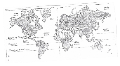
Name vegetation type marked 1,2, 3, and 4 (4marks) - Explain four ways in which trees in coniferous forests are adopted to the climatic condition (8marks)
- A form four Geography class is planning to carry out a field study in Kakamega forest.
- State how they would use the following tools during the study.
- A tape recorder (1mark)
- A sketch map (1mark)
- A camera (1mark)
- Give three methods they would use to collect the data during the study. (3 marks)
- State how they would use the following tools during the study.
-
-
- Differentiate between river catchment and watershed. (2marks)
- Describe three processes by which a river transports its load. (6marks)
- Explain three factors that lead to rejuvenation of a river. (6marks)
- Describe each of the following drainage patterns.
- Centripetal drainage pattern (2marks)
- Superimposed drainage pattern (3marks)
- You are to carry out a field study of a river within the vicinity of your school.
- State two reasons why you need a working schedule. (2 marks)
- State two characteristics of a river you are likely to observe in its lower course. (2 marks)
- State two follow up activities you are likely to carry out after the study. (2marks)
-
-
-
- Name two components of soils. (2 marks)
- State three characteristics of desert soils. (3 marks)
- List two factors that contribute to soil leaching. (2 marks)
- Describe how lateralization occurs. (6 marks)
- Explain how the following processes occurs.
- Splash erosion (2 marks)
- Gulley erosion (2 marks)
-
- What is soil conservation? (2 marks)
- Explain in three ways of maintaining soil fertility.
-

MARKING SCHEME
-
- What is the relationship between Geography and Chemistry (2marks)
-Chemistry principles are used by geographers in the studying the chemicals compositions of rocks and soil
-The chemical changes that take place in rocks and soil can best be analyzed and presented by geographers through the application of chemistry techniques. - State three reasons why the interior of the Earth is hot (3marks)
-Weight of overlying materials exert pressure resulting in heat
-Due to Radioactivity or nuclear fission
-Interior of the earth retained heat in the process of cooling after breaking from the sun.
- What is the relationship between Geography and Chemistry (2marks)
-
- Distinguish between Vulcanicity and Volcanicity (2marks)
-Vulcanicity is the process in which solids liquids or gaseous materials are forced out of the interior into the earths crust or onto the surface of the Earth
While
Volcanicity is a process in which igneous materials reach the surface of the earth.
Mark as a whole - Give two characteristics of basic lava domes (2marks).
-Have low heights
-Have a broad base
-Have gentle slopes
-Made up of several layers of basic lava.
- Distinguish between Vulcanicity and Volcanicity (2marks)
-
- what is desertification? (2marks)
-Desertification is the slow but steady encroachment of arid like conditions into formerly productive area.
Or
-Desertification is the process through which marginal lands are degraded through climatic variations and human activities. - State three negative effects of desertification (3marks)
-It leads to shortage of water / destruction of water catchment areas.
-It leads to drying of vegetation
-It leads to drying up of soil / development of fertile soils.
-It causes out migration of population
-It leads to wind erosion
-Development of infertile soil
- what is desertification? (2marks)
- The diagram below shows an upland area.
- Name the features P, Q and R (3 marks)
P - Pyramidal peak
Q - Arete
R- Hanging Valley - How is a U- shaped valley formed? ( 3marks)
-Glacier flows in an existing valley down hill
-It erodes vertically to deepen the valley
-It erodes laterally to widen the valley
-Resulting in U-shaped valley
- Name the features P, Q and R (3 marks)
-
- State three ways in which lakes are formed. ( 3marks)
-By process of erosion i.e water, wind , glacier and waves.
-By process of earth movement
-By process of Vulcanicity / Volcanic activity i.e lava flows, violent explosion
-By process of human activity
-By process of mass movements – land slides
-By process of falling of meteorite
-By process of carbonation i.e. solution action
-By process of deposition
Any 3 x 1 = (3marks) - Give two characteristics of lakes formed due to faulting. (2 marks)
-Most of the lakes are narrow
-Most of the lakes are steep sided boarded by steep sides
-Most of the lakes are deep
-Most of the lakes are salty
-Most of the lakes are long
Any 2 x 1 (2marks)
- State three ways in which lakes are formed. ( 3marks)
SECTION B
Answer question 6 and any other TWO questions from this section
- Study the map of Busia (1:50,000) sheet 101/1 provided and answer the following questions.
-
- Give the latitudinal and longitudinal position of South East corner of the map.(2marks)
-0o15’N, 34o15E. - Give two methods that have been used to represent relief. (2marks)
-contours
-trigonometrically station
- Give the latitudinal and longitudinal position of South East corner of the map.(2marks)
-
- What is the length in Kilometres of the All-weather loose surface road (C526) from the road junction at Odiado to the road junction at Bumula. (2marks)
-7.1 km - What is the bearing of the road junction at Matayo from the air photo principal point at Kisoko? (2marks)
-233o - Give three social services that are provided at Funyula. (3marks)
-commercial services
-transportation
-administration services
-recreation services
- Security
- What is the length in Kilometres of the All-weather loose surface road (C526) from the road junction at Odiado to the road junction at Bumula. (2marks)
- Describe the drainage of the area covered by the map. (6marks)
-The main drainage feature are rives.
-The other drainage features are swamps, dams, reservoirs.
-there are many rivers in the area.
-the rivers are permanent
-the rivers form dendritic pattern
-the main river is Sio.and it flows South Westwards.
-some rivers are bending / winding/ meandering
-some rivers are short and disappear underground e.g, R, Kiround and Wakgungu in the South.
-some rivers originate from the highland/around Samia hills. -
- Apart from trading, name two other economic activities in Busia area.(2marks)
-transportation
-cotton growing - Citing evidence from the map, explain three factors that favour trading in the area covered by the map. (6marks)
-the presence of numerous market centers/shops which provide opportunities for trading.
-the area has well developed transport network for delivery of goods and services shown by all-weather roads.
-the area is economically productive which provides good for trade evidenced by cotton farming/cotton store.
-there are numerous settlements which suggests availability of market for consumption of the variety of goods and services.
- Apart from trading, name two other economic activities in Busia area.(2marks)
-
-
-
- What is folding? (2marks)
-It is the process of crustal distortion which causes the rocks to bend upwards and downwards. - Name one country where the following fold mountains are found.
- Andes (1mark)
-Chile,Bolivia, Argentina, Venezuela, Ecuador Colombia - Atlas (1mark)
Morocco, Algeria, Tunisia
- Andes (1mark)
- What is folding? (2marks)
- The diagram below shows a types of fold.Name the feature marked x, y and z (3 marks)
X – Limb
Y – Anticline
Z – Syncline - With the aid of a labelled diagram, describe how an overthrust fold is formed. (6marks)
-layers of rocks of the earth’s crust are subjected to compressional forces.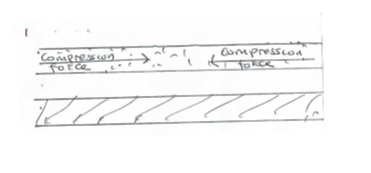
-Intense folding result in the formation of an over fold.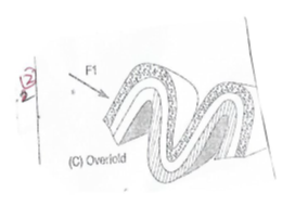
-with increased pressure, the over fold result in the formation of a recumbent fold.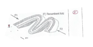
-when pressure is very great a fracture occurs along the axis in the recumbent fold producing a thrust plane.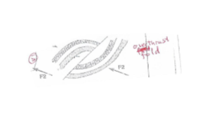
-the upper part of the recumbent fold slides forward over the lower part along the plane resulting to the formation of an over thrust fold. Diagrams. 2005 - Explain four effects of fold mountains on climate (8marks)
-the sun facing slopes are warmer than the opposite slopes because they are exposed to the sun.
-windward slopes of fold mountains receive higher precipitation than the leeward side because of orographic effect.
- Leeward side of fold mountain have caused Aridity
-fold mountains cause anabatic winds which have a cooling effect on the windward side while Katabaic winds on the leeward side cause a cooling effect on the valleys.
-fold mountains have an effect reducing pressure with increasing altitude
-the orographic effect of fold mountain leads to lower temperatures leading to formation of ice and snow. - Form four students in your school are planning to study land forms through field work. Give four reasons why it is important to study folded landforms through fieldwork.(4marks)
-Gives firsthand information.
-Application of knowledge gained to real life situation.
-development of various skills / application of skills learnt.
-helps in enhancing visual memory of landforms.
-Enables one to appreciate landforms.
-provides an in-depth learning / broader learning
-makes learning more interesting
-enables one to familiarize with the environment
(4 x 1= 4mark)
-
-
- Define the term vegetation (2marks)
-collective plants cover growing in a particular area/ is the plant cover that occurs naturally or widely on the earth surface. - Explain how the following factors influences the distribution of vegetation
- Aspect (2marks)
-Slopes facing the sun have a variety of plants due to warm summers.
-slopes not facing the sun hence few plants due to cool conditions or low temperatures. - Relief (3marks)
-Windward sides of mountains receive heavy rainfall leading to the growth of thick forests.
-tops of mountains have no or little vegetation cover due to little rainfall and very low temperatures.
-Gentle slopes have thick vegetation due to deep fertile soils.
- Aspect (2marks)
- The map below shows world vegetation zone. Name vegetation type marked 1,2, 3, and 4 (4marks)
1- tundra
2-equatonal forests
3-tropical grasslands
4-desert vegetation - Explain four ways in which trees in coniferous forests are adopted to the climatic condition (8marks)
-Needle – like leaves help to reduce loss of water in winter.
-The leaves have a tough waxy skin to protect them from cold winter
-The trees have a conical shape and flexible branches to allow snow to slide easily and to minimize damage to trees.
-Most trees are evergreen to minimize sunlight during the short growing season.
-The tree trunks are flexible to enable them sway without breaking during strong winds.
-The trees have thick barks with a lot of resin which protect them from frost.
4 x 2 = (8maks) - A form four Geography class is planning to carry out a field study in Kakamega forest.
- State how they would use the following tools during the study.
- A tape recorder (1mark)
-for recording conversations in the field.
-A sketch map (1mark)
-to fill in information during the study
-A camera (1mark)
Taking photographs of the forest. - Give three methods they would use to collect data during the study (3marks)
-observation
-interviewing
-sampling
-taking photographs
-digging
-smelling and feeling
-reading from books
(Any 3 x 1 = 3marks)
- State how they would use the following tools during the study.
- Define the term vegetation (2marks)
-
-
- Differentiate between river catchment and watershed. (2marks)
Catchment area is the land from which a river draws its water/source of a river.
While
A Watershed is a ridge/ highland area separating two drainage basins/river system. - Describe three processes by which a river transports its load. (6marks)
- Suspension - some materials like silt is carried in suspension because they are light and can be maintained within turbulence of the water.
- Solution – some of the load is dissolved in water and carried in solution form
- Saltation – some particles are fairly heavy and momentarily lifted by the turbulence of the water and then dropped onto the river bed.
- Transaction – large and heavy particles are rolled along the riverbed.
(3x2 = 6marks)
- Differentiate between river catchment and watershed. (2marks)
- Explain three factors that lead to rejuvenation of a river. (6marks)
- Dynamic rejuvenation local uplift of land leads to a change in the base level hence the river revives renews its erosive activities.
- Ecustatic rejuvenation lowering of the sea level creates sharp knick points at the river mouth thus increasing velocity of water hence renewing reverving its erosive activities.
- An increase of river discharge brought about a river capture leads to the revival/renewal of its erosive activities.
- Unequal regional subsidence of land a long a river course result in knick point thereby increasing the velocity of water down stream and hence revives its erosive activities.
- Changing rock resistance from hard to softer rocks along a river course.
- Increased precipitation in the catchment area of river increases the discharge raising the volume of a river thus increasing its erosive power / renews/ revives its erosive activities.
- Increase in precipitation in catchment areas of river increase the discharge raising volume of a river thereby increasing its power / renews/ revives its erosive activities
- Describe each of the following drainage patterns.
- Centripetal drainage pattern (2marks)
Centripetal drainage pattern. The pattern develops in an area with central basin / depression /hollow in which many rivers flow from all directions. (2marks) - Superimposed drainage pattern (3marks)
The drainage system develops on a rock structure that overlay a totally different one
The river valley cuts through the surface rock layer onto the underlying rocks
Gradually the surface rocks are removed and the underlying rocks now become exposed on the river bed.
The river maintains its original direction of flow despite the new structure. (3marks)
- Centripetal drainage pattern (2marks)
- You are to carry out a field study of a river within the vicinity of your school.
- State two reasons why you would need a working schedule. (2marks)
- it gives ample time to each activity.
-No activity is forgotten.
-It enables tendency of repeating facts.
-It provides an estimate.
-It provides estimation of the cost of the wholes study.
-It enables the research to remain in within the scope of topic. - State two characteristics of a river you are likely to observe in the lower course of the river. (2 marks)
-Alluvial fan
-Meanders and ox-bow lakes
-Natural levees and deferred tributaries
-Braided channels
-Deltas and distributaries
-Flood plain
-Very wide valley
(Any 2 x 1 = 2marks) - State two follow –up activities you are likely to carry out after the study. (2 marks)
-Class discussion
-Reading more about the topic
-Analyzing photographs / tape recorded
-Report writing
-Displaying the samples/specimen collected
-Class presentation
- State two reasons why you would need a working schedule. (2marks)
-
-
-
- Name two components of soil (2 marks)
- Air
- Water
- Organic matter / humus
- Inorganic matter/minerals
- State three characteristics of desert soils (3marks)
- They sandy
- They have low humus
- They are thin
- They are rich in calcium / lime content alkaline
- They are saline
(3 x 1 = 3marks)
- State two factors that contribute to soil leaching (2marks)
- Nature of the soil / solubility of the minerals / porosity
- Topography / relief
- High rainfall / alternating wet and dry seasons.
(2x1 = 2marks)
- Name two components of soil (2 marks)
- Describe how lateralization occurs (6marks)
- During the wet season, mineral salt in the top layer of the soil dissolves in rain water.
- The dissolved minerals are deposited further downwards to the lower layer. i.e elluviation .
- The dissolved mineral are deposited further downwards to the lower layer.
- Insoluble minerals such as iron and aluminum accumulate in the top layer to form laterite soil.
- Explain how the following process occurs. (2 marks)
- Splash erosion
Rain drops of heavy sudden rainstorms hit and loosen unconsolidated soil particles there by throwing soil particles away. - Gulley erosion
It occurs on steep slopes when rain water cuts deep grooves/channels on slopes to form rill. The channels are deepened and widened to form gullies. (2marks)
- Splash erosion
-
- What is soil conservation? (2marks)
Soil conservation are the measures taken to protect the soil from destruction - Explain three ways of maintaining soil fertility (6marks)
- Contour ploughing / ploughing across the slope form ridges and furrows that breaks the flow of the water downhill thus checking soil erosion.
- Crop rotation/planting different crops in successive years allows the soil to replenish hence the soil fertility is naturally maintained.
- Planting trees help reduce the runoff; leaves reduce the force of falling rain drops while the roots hold the soil particles together thus checking soil erosion
- In mixed farming, livestock feed on the remains. Livestock add fertility to the soil thereby enriching the soil with minerals and humus.
- Planting cover crops protects the top soil from the full force of heavy downpour.
- Regulating livestock and controlling grazing thereby reducing soil erosion.
- Regulating and checking the number of livestock thereby controlling overgrazing. This prevents exposing soil to erosion.
- Mulching protects soil from erosion and adds organic material / humus to the soil
(Any 3 x 2 = 6)
- What is soil conservation? (2marks)
-
Join our whatsapp group for latest updates
Tap Here to Download for 50/-
Get on WhatsApp for 50/-
Download GEOGRAPHY PAPER 1 - 2019 KCSE TAP TRIAL MOCK EXAMS (QUESTIONS AND ANSWERS).
Tap Here to Download for 50/-
Get on WhatsApp for 50/-
Why download?
- ✔ To read offline at any time.
- ✔ To Print at your convenience
- ✔ Share Easily with Friends / Students