
Questions
INSTRUCTIONS TO CANDIDATES
- This paper consists of two sections; section A and section B.
- Answer all questions in section A. In section B answer question 6 and any other two questions.
SECTION A
Answer ALL the questions in this section
- The diagram below shows the internal structure of the earth. Use to answer question (a)
and (b).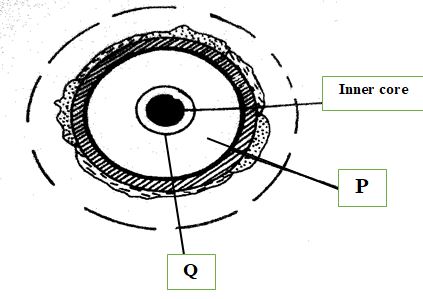
- Identify:
- the layer marked P. (1 mark)
- the zone of discontinuity marked Q. (1 mark)
- Give four characteristics of the core. (4 marks)
- Identify:
-
- What is a metamorphic rock? (2 marks)
- Give the metamorphic rock that form when the following rocks are metamorphosed:
- Granite (1 mark)
- Limestone (1 mark)
-
- Name two main continental plates. (2 marks)
- Describe how a subduction zone is formed. (3 marks)
- Use the diagram below to answer question (a)
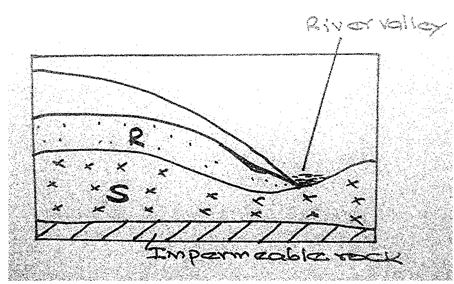
- Name the zones of saturation marked R and S. (2 marks)
- State three conditions necessary for the formation of an artesian well. (3 marks)
-
- What is a lake? (2 marks)
- Give three ways through which a lake is formed. (3 marks)
SECTION B: Answer Question six and any other Two Questions in this section. (75MKS)
- Study the map of Kijabe (1:50000) sheet 134/3 provided and answer the questions that follow
-
- What type map of is Kijabe extract? (1mk)
- Convert the map scale into statement scale (2mks)
-
- Measure the length of the railway line to the west of Easting 30 in kilometres. (2mks)
- Give six digit grid reference of the forest guard post. (2mks)
- Draw a square measuring 10cm by 10cm to represent the area enclosed by easting 30 and 40 and northings 90 and 00. (2mks)
On it mark and label;- Thicket vegetation (1mk)
- Railway line (1mk)
- Bore hole (1mk)
- River upper Ewaso Kedong (1mk)
- Describe the relief of the area shown by the map (5mks)
- Explain two factors influencing dairy farming in the area covered by the map (4marks)
- Citing evidence from the map, state three functions of Kijabe town (3mks)
-
-
-
- What is a weather station? (2mks)
- State four factors influencing the siting of a weather station. (4mks)
- Explain how the following factors affect temperature
- Aspect (2mks)
- Ocean currents (2mks)
- Altitude (2mks)
- Study the diagram below and use it to answer the questions that follow.
- Label the parts marked X ,Y and Z (2mks)
- Identify areas in Western Kenya where the phenomenon shown in the diagram above. Commonly occurs. (1mks)
- With aid of a well labeled diagram, explain formation of relief rainfall. (6mks)
- Give four reasons why weather forecasting is important. (4mks)
-
-
-
- Explain two causes of faulting (4marks)
- Identify two types of faults (2marks)
- With the aid of well labelled diagrams, describe the formation of the rift valley by compressional forces (8marks)
- Identify two examples of block mountains in East Africa (2marks)
- Explain two effects of faulting on drainage (4marks)
- Your class conducted a field study at the Great Rift Valley.
- State three reasons why it was important to seek for permission (3marks)
- Give two methods you used to collect data (2marks)
-
-
-
- Define the term glaciation. (2 marks)
- Name three types of glaciers. (3 marks)
- Give two reasons why there are no glaciers in Kenya. (2 marks)
- Explain how each of the following factors influence the movement of a glacier:
- Gradient of the slope. (3 marks)
- Temperature change (3 marks)
- Using a well labelled diagram, describe how a corrie lake is formed. (8 marks)
-
- The diagram below shows the type of moraines:
Name the type of moraine marked K and N. (2 marks) - State two negative effects of glaciation in lowland areas. (2 marks)
- The diagram below shows the type of moraines:
-
-
- Name any two cold deserts in the world. (2 marks)
- Describe three factors that influence wind transportation in desert areas. (6 marks)
- With the aid of well labelled diagrams, describe how a zeugen is formed. (8 marks)
- Give any three features formed by water erosion in desert landscapes. (3 marks)
- Explain three ways in which desert features are of significance to human activities. (6 marks)
Marking Scheme
- The diagram below shows the internal structure of the earth. Use to answer question (a)
and (b).- Identify:
- the layer marked P. (1 mark)
- P- Mantle
- the zone of discontinuity marked Q. (1 mark)
- Q- Gutenberg discontinuity
- the layer marked P. (1 mark)
- Give four characteristics of the core. (4 marks)
- Composed of two parts/ inner core and outer core.
- Main mineral of the outer core is iron and nickel.
- Main mineral of the inner core is iron
- The core has an average density of 12.0 gms/cc.
- The inner core has a density of 17.0 gms/cc.
- The outer core has an average density of 10.5gms/cc.
- The inner core is a solid rock mass.
- The rocks in the outer core are in molten state.
- The core has a high temperature of 4000-4500°C.
(any 4 x 1mk)
- Identify:
-
- What is a metamorphic rock? (2 marks)
- These are rocks that have undergone change both in character and appearance due to great heat and pressure.
- Give the metamorphic rock that form when the following rocks are metamorphosed:
- Granite - Gneiss (1 mark)
- Limestone- Marble (1 mark)
- What is a metamorphic rock? (2 marks)
-
- Name two main Continental plates. (2 marks)
- Eurasian plate,
- Australian plate
- African plate,
- Antarctic plate,
- N. American plate,
- S. American plate
- Describe how a subduction zone is formed. (3 marks)
- Occurs when an oceanic plate meets a continental plate.
- The edge of the oceanic plate slides beneath the continental plate because the oceanic plate is denser.
- This movement is called subduction.
- Name two main Continental plates. (2 marks)
- Use the diagram below to answer question (a)
- Name the zones of saturation marked R and S. (2 marks)
- R- Zone of intermittent saturation
- S- Zone of permanent saturation
- State three conditions necessary for the formation of an artesian well. (3 marks)
- The aquifer is sandwiched/lies between two impermeable layers of rock in order to retain water.
- The aquifer must be exposed on one or both end at the surface to allow rain water to percolate.
- The aquifer must be in a syncline to allow water to have sufficient pressure to flow out.
- The aquifer must outcrop in a region with adequate water supply to ensure permanent water supply.
- Name the zones of saturation marked R and S. (2 marks)
-
- What is a lake? (2 marks)
- A lake is an extensive body of water contained within a depression/ basin/ hollow on the surface of the earth.
- Give three ways through which a lake is formed. (3 marks)
- By earth movements e.g. faulting or folding
- By Volcanic activity/ by vulcanicity
- By erosion
- By deposition
- By human activities
- By falling of a meteorite
- By mass movement e.g. landslides
- By weathering by solution
- What is a lake? (2 marks)
- Study the map of Kijabe (1:50000) sheet 134/3 provided and answer the questions that follow
-
- What type map of is Kijabe extract? (1mk)
- Topographical map
- Convert the map scale into statement scale (2mks)
- 1cm represents 0.5 km
- What type map of is Kijabe extract? (1mk)
-
- Measure the length of the railway line to the west of Easting 30 in kilometres. (2mks)
- 8.1km
- Give six digit grid reference of the forest guard post. (2mks)
- 375948
- Measure the length of the railway line to the west of Easting 30 in kilometres. (2mks)
- Draw a square measuring 10cm by 10cm to represent the area enclosed by easting 30 and 40 and northings 90 and 00. (2mks)
On it mark and label;- Thicket vegetation (1mk)
- Railway line (1mk)
- Bore hole (1mk)
- River upper Ewaso Kedong (1mk)
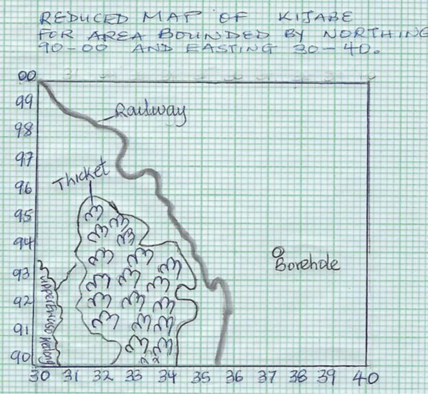
- Describe the relief of the area shown by the map (5mks)
- There are many river valleys in the areas
- There are hills in the area covered by the map e.g. Kijabe hill
- There are many river valleys in the area covered by the map such as the ones occupied by River Upper Ewaso Kedong and its tributaries
- There are gentle slopes to the south western part of the map
- There are steep slopes to the east of kijabe hill
- There is an escarpment to the east of Kijabe hill (any 5x1mk each)
-
- Explain two factors influencing dairy farming in the area covered by the map (6marks)
- Availability of pasture for the animals to graze as evidenced by the presence of thicket vegetation
- Availability of water for the animals to drink as evidenced the presence of many permanent rivers such as Upper Ewaso Kedong river
- Availability of a ready market for milk evidenced by the presence of many settlements at Kijabe
- Availability of transport for transporting milk to the collection centre/market/dairy as evidenced by the presence of dry weather road /all weather road loose surface E442/ all weather road bound surface A104
(any 2x2 marks)
- Siting evidence from the map, state three functions of Kijabe town (3mks)
- Residential centre- presence of houses and built up areas
- Transport centre- precence of railwail line, all weather road C68/ Dry weather roads E442
- Communication centre- post office
- Quarrying – quarry/ quarry pits
- Trade/ commercial centre- shops
- Medical centre – hospital
- Religious centre – mission
(any 3x1mark)
- Explain two factors influencing dairy farming in the area covered by the map (6marks)
-
-
-
- What is a weather station? (2mks)
- It is a place set aside for observation ,measurement and recording of elements of weather.
- State four factors influencing the siting of a weather station. (4mks)
- Open place for free circulation of air
- The site should provide a wide view of the surrounding landscape and the sky
- It should be located away from tall buildings, trees and structures to ensure wind approaching the station is not obstructed
- The ground should be gently sloping/fairly level
- The site should be free from flooding
(any 4x1 mark)
- What is a weather station? (2mks)
- Explain how the following factors affect temperature
- Aspect (2mks)
- The south facing and north facing mountain slopes in temperate regions of the Northern and Southern Hemispheres respectively are warmer than the slopes facing the poles because they receive direct sun rays/solar insolation.
- Ocean currents (2mks)
- Onshore winds crossing a cold ocean current bring a cooling effect to the adjacent coastal land thus lowering the temperatures
- Onshore winds crossing a warm ocean current bring a warming effect to the adjacent coastal land thus raising the temperatures
- Altitude (2mks)
- Temperatures decrease with increase in altitude because at high altitude the atmosphere is thin thus allowing rapid escape of terrestrial radiation to space
- Aspect (2mks)
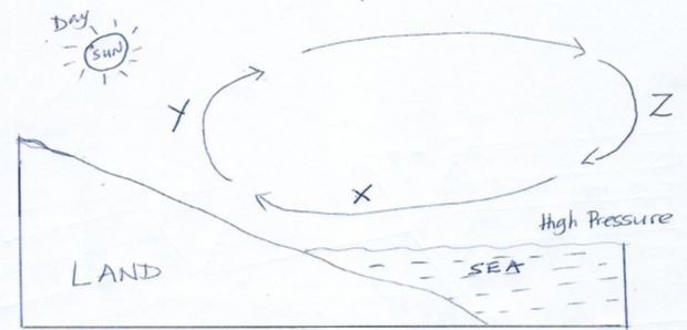
- Study the diagram below and use it to answer the questions that follow.
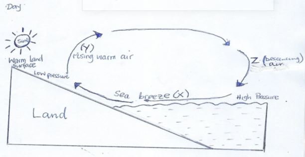
- Label the parts marked X and Y (2mks)
- X – Sea breeze
- Y – Ascending /rising air
- Z – descending air
- Identify areas in western Kenya where the phenomenon shown in the diagram above commonly occurs. (1mks)
- Near lakes such as around L. Victoria
- Label the parts marked X and Y (2mks)
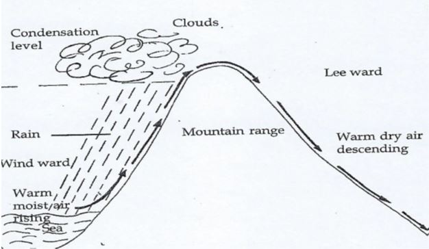
- With aid of a well labeled diagram, explain formation of relief rainfall. (6mks)
- A water body/sea/lake is heated causing evaporation of water
- Moist air from the sea is forced to ascend up the hill/mountain side
- Forced ascent leads to cooling of air
- The moisture /water vapor condenses to form clouds and rain mainly fall on the windward side of the hill/mountain.
- Cool dry winds descend on the leeward slopes leading to dry conditions.
- Give four reasons why weather forecasting is important. (4mks)
- It enables farmers to plan their farming activities
- Helps people to determine suitable clothing for the day
- It influences designing of suitable houses
- Helps to determine air and sea travel/ guides the landing and takeoff of aircrafts
- Helps to plan for sporting activities/ military activities
- It guides fishermen in their fishing activities
-
-
-
- state three causes of faulting (3marks)
- Tear/shear forces cause the movement of landmasses alongside each other in opposite directions forming tear/shear fault
- Compressional forces push landmasses towards each other resulting in formation of reverse faults.
- Tensional forces pull apart landmasses resulting in the formation of normal faults.
(3x1mark)
- Identify three types of faults (3marks)
- Normal faults
- Reverse faults
- Anticlinal faults
- Thrust fault
- Shear/tear/slip/wrench fault
(any 3x1mark)
- state three causes of faulting (3marks)
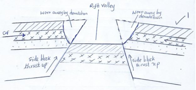
- With the aid of well labelled diagrams, describe the formation of the rift valley by compressional forces (8marks)
- Layers of crustal rocks are subjected to compressional forces
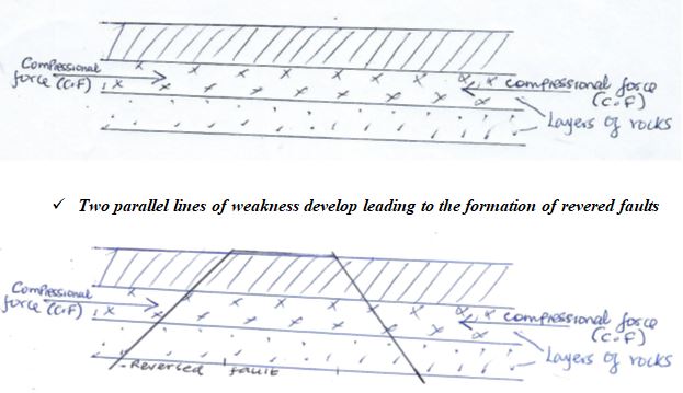
- Compressional forces may push the outer blocks towards each other. The outer blocks ride over the middle block and the middle block sinks or subsides or may remain stable but at a lower level, forming the floor of the rift valley.
- The sunken middle part forms a trough/depression called a rift valley
- The overhanging parts gradually collapse and are eroded to form escarpments
- Layers of crustal rocks are subjected to compressional forces
- Identify two examples of block mountains in East Africa (2marks)
- Aberdare ranges
- Ruwenzori mountains
- Explain two effects of faulting on drainage (4marks)
- Faulting may lead to the formation of an escarpment with springs forming at the base due to exposure of the water table
- Faulting across a river valley followed by vertical displacement of land may lead to the formation of a water fall where it descends the formed escarpment.
- When faulting occurs across a river valley, it may cause the river to disappear into the ground through a fault line
- Uplifting of land which follows faulting may block a river causing it to reverse its direction or change its flow.
- Some rivers flow along fault-lines thus forming a fault-guided drainage pattern
- Your class conducted a field study at the Great Rift Valley.
- State three reasons why it was important to seek for permission (3marks)
- Enables the school administration to arrange for transport/lunch/meals
- It is an official requirement
- For the principal to alert other teachers on the disruption of the school routine
- For the administration to provide essential tools for use
- Enables school administration to provide entry fee if required
- To avoid being denied access in the place you intend to visit
- For the authorities to arrange for a tour guide to take them around
(Any 3 x 1 mark)
- Give two methods you used to collect data (2marks)
- Observation
- Interviewing
- Administering questionnaires
- Photographing
(2x1mark each)
- State three reasons why it was important to seek for permission (3marks)
-
-
-
- Define the term glaciation. (2 marks)
- The process through which moving ice erodes, transports and deposits materials on the earth’s surface.
- Name three types of glaciers. (3 marks)
- Valley glacier
- Cirque glacier
- Piedmont glacier
- Continental glacier/Ice sheets
- Give two reasons why there are no glaciers in Kenya. (2 marks)
- Kenya experiences high temperatures under which ice sheets cannot form.
- Most parts of Kenya are in the lowlands where the temperatures are high.
- Kenya is found at low altitude regions/Equatorial area.
- Define the term glaciation. (2 marks)
- Explain how each of the following factors influence the movement of a glacier:
- Gradient of the slope. (3 marks)
- A steep gradient causes faster movement of the glacier due to greater effect of gravity.
- A gentle gradient causes slow movement of the glacier due to less effect of gravity.
- Flat/plain leas lead to stagnation of the glacier.
- Temperature change (3 marks)
- Glaciers move faster in summer or when the temperatures are higher because the ice melts due to the warm conditions.
- During winter or when the temperatures are low, ice movement is slow due to cold conditions.
- The temperature of the bottom of the valley glacier rises with increased pressure causing thawing and thus enabling movement downslope (3X1=marks)
- Gradient of the slope. (3 marks)
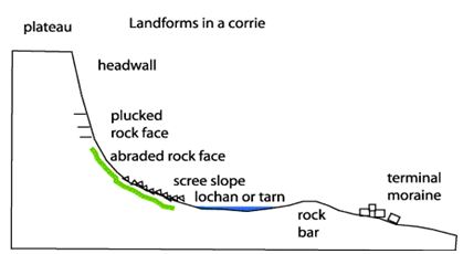
- Using a well labelled diagram, describe how a corrie lake is formed. (8 marks)
- Snow accumulates in a shallow pre-existing depression on a mountain side
- The snow gets compacted into ice.
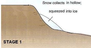
- Through freezing and thawing, the depression becomes larger.
- More ice occupies the depression to form cirque glacier.
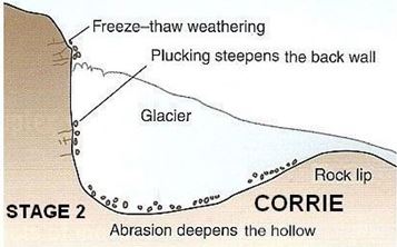
- The ice moves downslope and erode the depression by abrasion at the bottom to make it deep and plucking on the walls to make it steep.
- Further plucking and abrasion enlarge and deepen the hollow.
- Eventually a deep steep sided arm chair shaped depression known as a corrie is formed.
- The depression is filled by meltwater/rain water to form a lake known as a tarn.
-
- The diagram below shows the type of moraines:
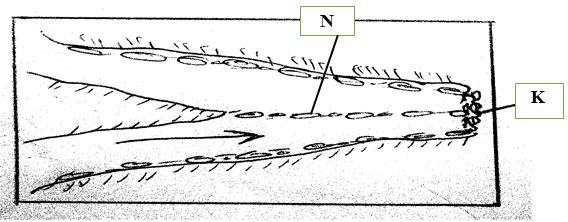
Name the type of moraine marked K and N. (2 marks)- K- Terminal moraine
- N- Medial moraine
- State two negative effects of glaciation in lowland areas. (2 marks)
- Boulder clay deposits in lowlands lead to the formation of marshy and bog landscapes which are poorly drained and thus discourage agriculture.
- Some depositional features such as till and outwash plains contain infertile soils which discourage agriculture.
- Glaciation leads to the formation of rugged landscape which make it difficult to construct transport lines and settle.
- Glacial deposition leads to the formation of glacial lakes which limit/reduce the amount of land available for man’s activities e.g. in the Canadian shield.
- The diagram below shows the type of moraines:
-
-
- Name any two cold deserts in the world. (2 marks)
- Gobi
- Patagonia
- Utah
- Nevada
- Mongolia
- Turkestan
- Kazakhstan
- Uzbekistani
- Describe three factors that influence wind transportion in desert areas. (6 marks)
- Strength and speed of the wind
- Strong and fast wind transport more and heavier materials over long distances because it has greater energy.
- Absence of obstacles on the path of wind
- The absence of obstacles on the path of the wind will encourage transportation of materials because there is nothing to interfere with the wind speed.
- The presence of obstacles e.g. large pieces of rock blocks the wind thus reducing its speed. This causes the wind to drop its load
- Vegetation cover or water mass
- Absence of vegetation cover or a water body encourage transportation of materials by wind since the soil/sand is exposed to the surface.
- The presence of vegetation covers or a water mass slows down wind transport because the soil/sand are bound together. This reduces the ability of the wind to the sand and soil particles.
- Nature of the load
- Small particles such as dust are transported by wind over long distances because they are light. larger particles such as sand are transported along the ground or rolled along the ground because they are heavy.
- Weather changes
- Periodic weather changes cause the rate of wind transportation to change e.g. when torrential rain falls, the materials that were airborne are washed down to the ground and thus transport ceases.
- Dry conditions encourage wind transport because the sand and soil particles are loose and unconsolidated because there is no moisture to bind them
- Strength and speed of the wind
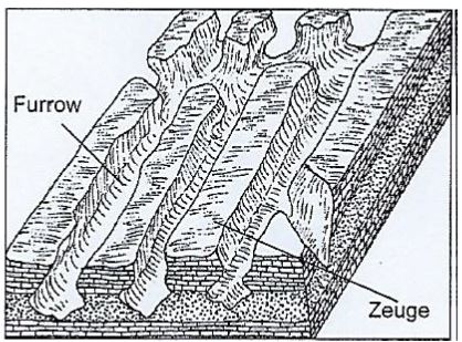
- With the aid of well labelled diagrams, describe how a zeugen is formed. (8 marks)
- Zeugen are formed in desert areas where alternating horizontal layers of hard and soft rocks occur.
- The top layer of hard rock is jointed or has cracks.
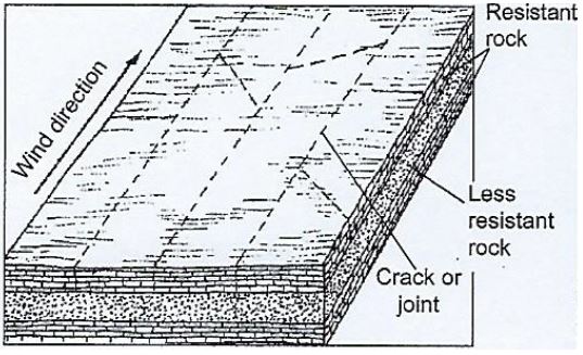
- Weathering opens up the joints.
- Wind abrasion erodes the joints deepening and widening them to reach the soft layer of rocks
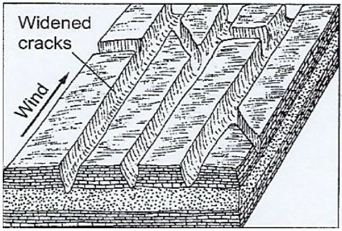
- Deflation process blows away the loose broken materials.
- Abrasion continues into the soft rock.
- The hard resistant rock forms ridges separating furrows.
- This process produces a ridge and furrow landscape.
- The ridges are known as zeugen
- Give any three features formed by water erosion in desert landscapes. (3 marks)
- Wadi
- Canyon
- Alluvial fans and bajadas
- Pediments and inselbergs
- Dry river valley
- Explain three ways in which desert features are of significance to human activities. (6 marks)
- Desert features such as sand dunes/yarding/zeugen/rock pedestals form good sites for tourist attractions thereby earning foreign exchange.
- Deflation hollows containing oases are sources of water for domestic/agricultural use.
- Wind deposited soil/loess form fertile plains for farming.
- Salt flats are economically used for salt production.
- Shifting sand dunes form barriers across roads and hinder transport activities.
- Desert sceneries are ideal for film making.
- Vast sand seas are ideal for military training/testing of nuclear weapons.
- Extensive and bare desert surfaces are testing grounds for car and jet engines.
- Name any two cold deserts in the world. (2 marks)
Join our whatsapp group for latest updates
Tap Here to Download for 50/-
Get on WhatsApp for 50/-
Download Geography Paper 1 Questions and Answers - KCSE 2021 Westlands Mock Exams.
Tap Here to Download for 50/-
Get on WhatsApp for 50/-
Why download?
- ✔ To read offline at any time.
- ✔ To Print at your convenience
- ✔ Share Easily with Friends / Students