
SECTION A
Answer all questions in this section
-
- Name two layers of discontinuity in the earth’s interior (2 marks)
- State three characteristics of the outer core in the internal structure of the earth (3 marks)
-
- Name two types of earth movements. (2 marks)
- The diagram below represents tectonic plate boundary.
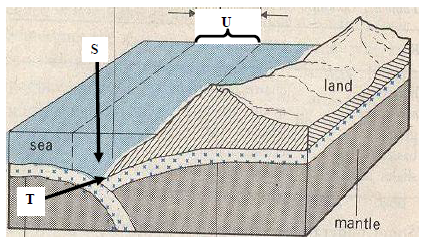
- Name the features marked S, T, and U. (3 marks)
-
- Differentiate between seismic focus and epicenter. (2 marks)
- Name two types of surface longitudinal waves. (2 marks)
-
- Apart from exfoliation, name two other physical weathering processes influenced by temperature changes (2 marks)
- Describe exfoliation process. (3 marks)
-
- Name two main sources of underground water. (2 marks)
- How is a limestone pillar formed? (4 marks)
SECTION B:
Answer question 6 and any two other questions from this section.
- Study the map of Yimbo 1:50,000(sheet 115/1) provided and answer the following questions.
-
- Give the title and sheet number of the map extract. (2Marks)
- What is the six figure Grid Reference of the Trigonometrical.
Station at Abiero Hill on the South Eastern area of the map? (1Mark) - Name the height of the highest point in the area covered by the map. (1Mark)
-
- Calculate the area of Yala swamp found to the north of
Regional Boundary. Give your answer in Km2. (2Marks) - Citing evidence from the map identify two economic activities carried out in the area. (2Marks)
- Calculate the area of Yala swamp found to the north of
-
- Using a vertical scale of 1cm represent 20 metres, draw a cross- section along Northing 80 from Easting 30 to Easting 39. (4Marks)
- On the cross-section, mark and name the following:
- All weather road:- loose surface
- Indefinite River
- Motorable track (3Marks)
-
- Describe the distribution of natural vegetation in the area covered by the map. (4Marks)
- Explain three factors, which have influenced the distribution of Settlement in the area. (6Marks)
-
-
-
- Name two forces that are responsible for the varied shapes
of planet earth (2 marks) - State two ways through which geographers gather information about the internal part of the earth (2 marks)
- Describe the origin of the earth according to the Nebula Cloud Theory (5 marks)
- Name two forces that are responsible for the varied shapes
-
- Differentiate between Revolution and Rotation of the earth. (2 marks)
- When it is noon in London (0º), what is the East African
Standard time? (2 marks) - Outline three effects of the rotation of the earth (3 marks)
-
- Apart from autumn name three other seasons that occur
on the earth (3 marks) - Describe three climatic conditions associated with autumnal
season (6 marks)
- Apart from autumn name three other seasons that occur
-
- Use the map below to answer questions a (i) and (ii).
-
- Name three natural types of forests marked J and K. (2 marks)
- Explain how the vegetation marked J is adapted to the climatic conditions. (6 marks)
- Explain how the following factors influence distribution of vegetation.
- Soils (2 marks)
- Wind (2 marks)
- Slope (2 marks)
- State five characteristics of tropical savanna grasslands. (5 marks)
- A group of geography students are planning to carry out a field study on vegetation in Nandi County.
- State three reasons why sampling would be appropriate for this study. (3 marks)
- Apart from collecting samples, state three other primary methods they would use to collect data on vegetation while in the field. (3 marks)
-
-
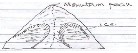
- Name two types of glaciers which are found on mountains in
East Africa. (2 marks) - Explain how the following factors influence erosion by a glacier.
- Nature of the underlying rock. (2 marks)
- Speed of the glacier. (2 marks)
- Thickness and weight of ice. (2 marks)
- With the aid of labeled diagrams, describe how an arête is
formed. (6 marks) -
- Describe the process through which a Roche moutonnee
is formed. (5 marks) - Explain the significance of glaciated features to human
activities. (6 marks)
- Describe the process through which a Roche moutonnee
- Name two types of glaciers which are found on mountains in
-
- Identify three processes of wind erosion in desert areas. (3 marks)
- Explain three factors Influencing wind deposition in arid areas. (6 marks)
- The diagram below shows some features found in a desert landscape. Use it to answer the following questions:
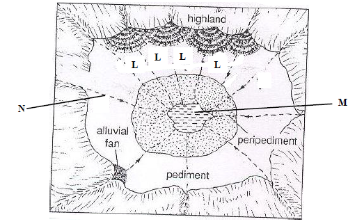
- Identify the landscape shown in the diagram. (1 mark)
- Name the features marked L, M and N. (3 marks)
- Describe how feature marked L is formed. (4 marks)
- Explain four negative effects of deserts to human activities (8 marks)

Marking Scheme
-
- Name two layers of discontinuity in the earth’s interior (2 marks)
- Mohorovicic/Moho discontinuinity
- Gutenberg discontinuity
- State three characteristics of the outer core in the internal structure of the earth (3 marks)
- Forms the continental crust/upper crust
- Consist mainly of silica and aluminium
- Made up of light rocks/2.7g/cc/floats on SIMA
- Made up of granitic/sedimentary/metamorphic rocks
- Made up of rigid/brittle rocks
- Name two layers of discontinuity in the earth’s interior (2 marks)
-
- Name two types of earth movements. (2 marks)
- Horizontal earth movement
- Vertical earth movement
- The diagram below represents tectonic plate boundary.
- Name the areas marked S, T, and U. (3 marks)
S - Oceanic trench
T - Destructive boundary
U - Subduction zone
- Name the areas marked S, T, and U. (3 marks)
- Name two types of earth movements. (2 marks)
-
- Differentiate between Seismic focus and epicenter. (2 marks)
- Seismic focus is the origins of shock waves inside the earth’s crust.
- The epicenter is the point on the earth’s surface vertically above the focus.
- Name two types of surface longitudinal waves. (2 marks)
- Rayleigh waves
- Love waves
- Differentiate between Seismic focus and epicenter. (2 marks)
-
- Apart from exfoliation, name two other physical weathering processes influenced by temperature changes (2 marks)
- Block disintegration/block separation
- Granular disintegration
- Crystal growth
- Describe exfoliation process. (3 marks)
- Exfoliation occurs within rocks of uniform structure mainly in arid and semi-arid areas
- During the night, temperatures are high and the rocks are heated on the surface making the surface expand (the inner core is cooler and does not expand)
- During the night, temperatures are lower and the rocks will and contract on the surface
- Continued expansion and contraction makes the rock surface to develop cracks which will finally break and peel off in curved sheets, this is exfoliation
- Apart from exfoliation, name two other physical weathering processes influenced by temperature changes (2 marks)
-
- Name two main sources of underground water. (2 marks)
- Rainwater
- Melt water
- Lake and sea water
- Magmatic water
- How is a limestone pillar formed? (2 marks)
- It is formed inside a Cavern in a limestone area where a stalagmite and a stalactite form.
- Both the stalagmite and stalactite grow towards each other, eventually meeting to form a continuous column that resembles a pillar. This is a limestone pillar.
- Name two main sources of underground water. (2 marks)
- Study the map of Yimbo 1:50,000(sheet 115/1) provided and answer the following questions.
-
- Give the title and sheet number of the map extract. (2mks)
- East Africa 1:50000 (Kenya/Uganda), sheet 115/1
- What is the six figure Grid Reference of the Trigonometrical Station at Abiero Hill on the South Eastern area of the map? (1mk)
- 391806 - Name the height of the highest point in the area covered by the map. (1mk)
- 1318 meters
- Give the title and sheet number of the map extract. (2mks)
-
- Calculate the area of Yala swamp found to the north of Regional Boundary. Give your answer in Km2. (2mks)
- Full sqs =5
- ½ sqs =9/2=4.5
- Total area =5+4.5=9.5±0.5km² - Citing evidence from the map identify two economic activities carried out in the area. (2mks)
- Crop/cereals/grains growing evidenced by presence of posho mill
- Mining evidenced by mineral workings/gold mine
- Trade evidenced by presence of several markets
- Transport evidenced by presence of port, ferry, roads
- Calculate the area of Yala swamp found to the north of Regional Boundary. Give your answer in Km2. (2mks)
-
- Using a vertical scale of 1cm represent 20 metres, draw a cross-section along Northing 80 from Easting 30 to Easting 39. (4mks)
CROSS-SECTION ALONG NORTHING 80 FROM EASTING 30 TO 39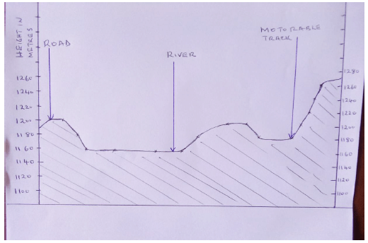
Title 1mk
Vs 1mk
Tr 1mk
Sp ½mk
Ep ½mk
River 1mk
Road 1mk
Track 1mk - On the cross-section, mark and name the following:
- All weather road:- loose surface
- Indefinite River
- Motorable track (3mks)
- Using a vertical scale of 1cm represent 20 metres, draw a cross-section along Northing 80 from Easting 30 to Easting 39. (4mks)
-
- Describe the distribution of natural vegetation in the area covered by the map. (4mks)
- Papyrus vegetation dominates Yala swamp/NW area and along River Yala in NE area
- Thicket vegetation is found in areas such as Mageto Island, Ogare hill, Ramogi hill
- Scrub vegetation is found in several place such as around Migwena/Eastern side of the area covered by the map, north eastern sides
- Woodland vegetation dominates the north eastern side of the area covered by the map
- Explain three factors which have influenced the distribution of Settlement in the area. (6mks)
- Transport:
- Along the roads/motorable tracks/footpaths, there is linear settlement
- At road junctions there are clustered/nucleated settlements - Vegetation:
- there are no/few settlements within the woodlands/thickets/areas where there are papyrus swamp vegetation
- most areas covered by scrub/scattered trees have clustered/nucleated settlement - Relief:
- There are no/few settlements on the hills, isolated islands in the lake.
- There are clustered/nucleated settlements on the undulating land - Drainage:
- There are no settlements in the areas having seasonal/papyrus swamps - Market:
- Market centers have dense/nucleated/clustered settlements
- Transport:
- Describe the distribution of natural vegetation in the area covered by the map. (4mks)
-
-
-
- Name two forces that are responsible for the varied shapes of planet earth (2 marks)
- Centrifugal
- Centripetal
- Gravity/force of gravity/gravitational force
- State two ways through which geographers gather information about the internal part of the earth (2 marks)
- Carrying out seismic experiments/studies
- Crustal boring/drilling
- Studying of volcanic materials extruded on the earth’s surface
- Describe the origin of the earth according to the Nebula Cloud Theory (5 marks)
- The explosion of the stars led formation of a huge cloud of gases (hydrogen and helium), dust and ice pellets
- The cloud of gases whirled. Cooled and condensed to a disc shape
- The gravitational attraction within the material increased and caused the particles to compact
- Some particles broke from the edge of the disc and whirled
- The compacted particles whirled faster towards the centre of the disc in different directions.
- As they whirled in different directions they cooled and solidified to form planets
- The swirling caused particles to collide losing a little energy at a time
- The of the spinning disc condensed to form the sun while the material spinning around condensed into large chunks of materials called planetoids
- The planetoids collided and coalesced into large bodies called planets
- The earth is one of them
- The centre of the disc formed the sun.
- Name two forces that are responsible for the varied shapes of planet earth (2 marks)
-
- Differentiate between Revolution and Rotation of the earth (2 marks)
- Revolution is movement of the earth around the sun following a path called orbit while Rotation is the spinning/movement of the earth on its own axis
- When it is noon in London (0º), what is the East African Standard time? (2 marks)
12.00+3hrs=1500hrs or 3.00p.m.
(NB East African time zone is 3hrs ahead of London) - Outline three effects of the rotation of the earth (3 marks)
- Causes the occurrence of day and night
- Causes deflection of winds and ocean currents
- Causes the rising and falling of ocean tides
- Causes variation in time at different longitudes
- Causes difference in atmospheric pressure on the surface of the earth
- Differentiate between Revolution and Rotation of the earth (2 marks)
-
- Apart from autumn name three other seasons that occur on the earth (3 marks)
- Summer
- Spring
- Winter
- Describe three climatic conditions associated with autumnal season (6 marks)
- Temperatures begin to drop
- The air starts becoming cool and eventually chilly
- Hours of sunlight begin to reduce and nights become longer
- The sky becomes hazy/misty
- Towards the end of the season, snow instead of rain, begins to fall
- Apart from autumn name three other seasons that occur on the earth (3 marks)
-
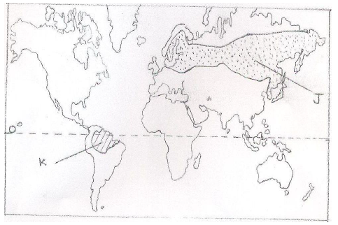
- Use the map below to answer questions a (i) and (ii).
-
- Name the types of forests marked J and K. (2 marks)
J - Coniferous forests
K - Equatorial/tropical rain forests - Explain how the vegetation marked J is adapted to the climatic conditions. (5 marks)
- The tree have needle like leaves which were to reduce loss of water in winter when there is no moisture to be absorbed from the soil.
- The leaves have a tough waxy skin which protect them from winter cold.
- The trees are conically shaped and this allows snow to slide off easily.
- The trees have flexible branches that allow snow to easily slide, hence reducing drainage to the trees.
- Most of the trees are evergreen to allow maximum use of sunlight during the short growing season
- The tree trunks are flexible hence able to sway without breaking during strong winter winds.
- The trees have a widely spread shallow to utilize from the topsoil.
- Name the types of forests marked J and K. (2 marks)
- Explain how the following factors influence distribution of vegetation.
- Soils (2 marks)
- Areas of deep, well drained fertile soils where large varieties of plants e.g. forests.
- Areas of poorly drained shallow and infertile soils have few varieties of plants, hence such areas are dominated by scattered trees, shrubs and grasslands.
- Wind (2 marks)
- Hot dry winds created during hot conditions, leading to scanty vegetation in an area e.g. scattered trees.
- Moist winds bring in rainfall hence growth of thick vegetation cover e.g. forests.
- Winds disperse seeds hence establishment of plants in certain areas.
- Slope (2 marks)
- On steep slopes there is little/scanty vegetation cover due to high of soil erosion by raining water.
- Gentle slopes have of vegetation because they are well drained.
- Flat areas in areas of high rainfall will have poor drainage thus encourage the growth of swamp plants.
- Soils (2 marks)
- State five characteristics of tropical savanna grasslands. (5 marks)
- Consist of a mixture of trees and grass.
- Grass is the dominant type of vegetation of the savanna.
- Most of the trees are umbrella-shaped.
- The common tree species are acacia, baobab, palms and ceiba.
- Some trees are stunted barks and are drought resistant.
- Most of the trees shade their leaves during the dry season and the grass withers and dry up.
- Some of the trees have long tap roots which develop in the ground.
- Some of the trees like baobab have thick stems.
- Along some river valleys there are tall trees and thick bushes
- A group of geography students are planning to carry out field study vegetation in Nandi County.
- State three reasons why sampling would be appropriate for this study. (3 marks)
- Saves time
- Would be less expensive
- Enables them to relevant areas.
- Sampling allows detailed study
- Sampling reduces bias in data collection.
- Vegetation grows randomly so random sampling is appropriate.
- A county is too large to be covered as a whole.
- Apart from collecting samples, state three other primary methods they would use to collect data on vegetation while in the field. (3 marks)
- Observation of the vegetation to determine the types.
- Measuring weights of the trees
- Counting number of plants in a given area.
- Touching/feeling the leaves to determine their texture.
- Taking photographs of the vegetation.
- Tasting some leaves from the roots.
- Interview the resource person in the forest department in the county.
- State three reasons why sampling would be appropriate for this study. (3 marks)
-
-
- Name two types of glaciers which are found on mountains in East Africa. (2 marks)
- Ice caps
- Cirque glaciers
- Valley glaciers
- Explain how the following factors influence erosion by a glacier.
- Nature of the underlying rock. (2 marks)
- Softer rocks are eroded faster by ice abrasion than harder ones.
- Well-jointed rocks/rocks with faults and cracks are eroded faster/easily by plucking than smooth ones.
- Speed of the glacier. (2 marks)
- A fast moving glacier erodes move than a slow moving glacier because it has more energy.
- Thickness and weight of ice. (2 marks)
- Thicker ice is heavier and thus erode the rocks more by abrasion because it exerts more pressure.
- Nature of the underlying rock. (2 marks)
- With the aid of labeled diagrams, describe how an arête is formed. (6 marks)
- Snow accumulates in several hollows on mountain sides.
- The snow gets compacted into ice.
- The plucking action of ice enlarges the hollows allowing more ice to collect in them.
- Freeze-thaw action enlarges the hollows to form large basings/cirques.
- The hollow is enlarged and deepened by the cirque glacier through plucking and abrasion.
- Nivation eats into the backwalls of the depressions making them recede into the mountain side.
- Steep-sided knife edged ridges called arêtes are formed separating the basins.
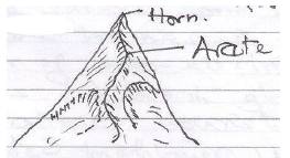
Text = 4 marks
Diagram = 2 mks
-
- Describe the process through which a roche moutonnee is formed. (5 marks)
- A large block of a more resistant rock stands on the path of on coming glacier in a low lying area.
- The more resistant rock is eroded at a slower rate than the surrounding rocks.
- The moving ice erodes the upstream side more evenly and it smoothens its surface by abrasion with time.
- As the ice moves over the downstream side, it erodes by plucking process.
- When the ice retreats, it exposes the resistant rock.
- The rock outcrop has a gentle smoothened upstream side and a steep, rugged downstream side formed is called roche moutonnee.
- Explain the significance of glaciated features to human activities. (6 marks)
- Hanging valleys form water falls, which are harnessed for the generation of hydro-electric power.
- Features found in glaciated areas attract tourists.
- In glaciated highlands, u-shaped valleys floors provide suitable areas for settlement/agriculture/communication routes.
- Melting glaciers are sources of rivers which provide water for domestic/industrial/agriculture base.
- Alluvial fans/out-wash plains have fertile soils suitable for agriculture.
- Fiords provide suitable sites for development of harbours.
- Fiords provides sheltered waters suitable for fish breeding. This promotes fishing.
- Describe the process through which a roche moutonnee is formed. (5 marks)
- Name two types of glaciers which are found on mountains in East Africa. (2 marks)
-
- Identify three processes of wind erosion in desert areas. (3 marks)
- Abrasion
- Deflation
- Attrition.
- Explain three factors Influencing wind deposition in arid areas (6 marks)
- Presence of obstacles such as rocks, bushes and shrubs in the path of prevailing wind creates friction have wind drops some of its load.
- Wind carrying too many particles it may lead to some of the load to the deposited
- Sudden down pour experienced in deserts may lead to some practices carried by wind & suspended in the air may be washed down and have deposited.
- When the strength of wind slackens, there may be deposition of load.
- Occurrence of a water surface or a moist ground along a desert landscape leads to friction have deposition of materials.
- The diagram below shows some features found in a desert landscape. Use it to answer the following questions:
- Identify the landscape shown in the diagram. (1 mark)
- Inland Drainage basin in a desert landscape.
- Name the features marked L, M and N (3 marks)
X - Bajada
Y - Playa
Z - Seasonal Stream - Describe how the feature marked L is formed.. (4 marks)
- It is formed when many adjacent alluvial fans/ cones merge together to form a continuous underlaying features composed of coarse sand, - and fine deposits at the foot of slopes, forming a bajada/ bahada sloping to the centre of the basin.
- Identify the landscape shown in the diagram. (1 mark)
- Explain four negative effects of deserts to human activities (8 marks)
- Formation of sand dunes across transport and communication lies makes transportation of goods and people difficult.
- Migrating sand dunes may destroy settlements and farm lands causing loss of life and human property.
- Scarcity of vegetation and water makes such areas less habitable discouraging human activities
- Sudden rainy storms may lead to flash flooding causing destruction of property and loss of human life in settled areas and along the wadis.
- Identify three processes of wind erosion in desert areas. (3 marks)
Join our whatsapp group for latest updates
Tap Here to Download for 50/-
Get on WhatsApp for 50/-
Download Geography Paper 1 Questions and Answers - Kapsabet Mocks 2020/2021.
Tap Here to Download for 50/-
Get on WhatsApp for 50/-
Why download?
- ✔ To read offline at any time.
- ✔ To Print at your convenience
- ✔ Share Easily with Friends / Students