
Instruction:
- Answer ALL the questions in section A.
- In Section B answer question 6 and any other two.

QUESTIONS
SECTION A:
-
- Name two branches of geography. (2mks)
- Give three reasons why it is important to study geography. (3mks)
-
- What is solar insolation? (2mks)
- Outline three importance of moisture in the atmosphere. (3mks)
-
- State two effects of the rotation of the earth on its axis. (2mks)
- The local time at manual 600W is 11.30 am. What is the time in Nairobi 370E? (3mks)
-
- What is an ice sheet? (2mks)
- State three ways in which ice moves (3mks)
-
- Name the two types of waves experienced in the coastal area. (2mks)
- List three coastal features which result from wave deposition. (3mks)
SECTION B:
Answer question 6 and any other two questions.
- Study the map of Kijabe 1 : 50,000 (sheet 134/3) provided and answer the following questions.
-
- Give the longitudinal extent of the area covered by the map. (2mks)
- Identify the two human made features found at grid square 3301 (2mks)
- what is the bearing of the cattle dip at Ewaso kedong valley from grid reference 3195( 2mrks
-
- calculate the area covered by thicket vegetation in the area covered by the map (3mks)
- measure the length of all weather road bound surface C68 and give your answer in km. (2 maks)
-
- Give three evidences showing that the area receives high rainfall (3marks)
- Citing evidence from the map, identify three economic activities practiced in the area covered by the map (6maks)
- Describe the drainage of the area covered by the map. (5mks)
-
-
- State two factors which influence the occurrence of underground water (2mks)
- Differentiate between a well and spring. (2mks)
- The diagram below represent an artesian basin. Use it to answer question C (i) and (ii)
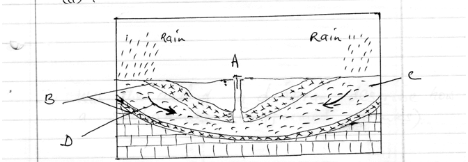
- Name the parts marked A, B, C (3mks)
- Identify the process marked D. (1mk)
- State three factors which favour the location of an artesian well (3mks)
-
- Apart from stalagmites name three other underground features formed in limestone areas. (3mks)
- With the aid of a diagram describe how a stalagmite is formed (6mks)
-
- State three reasons why there are few settlements in Karst Landscapes. (3mks)
- Name two surface features found in limestone areas. (2mks)
-
- With the aid of well labelled diagrams describe the processes involved in the formation of a corrie lake. (8mks
- Explain four ways in which a glaciated landscape is of significance to human activities. (8mks
- Explain three conditions that may lead to glacial deposition in lowlands. (3mks)
- Suppose students were to carry out a field study on glaciation on Mt.Kenya
- Name two types of morains they are likely to study. (2mks)
- State two problems they are likely to experience during the field study. (2mks)
- Why was it important for the learners to conduct a pre-visit (2mks)
-
- Describe podzolization as a process of leaching. (4mks)
- State three ways in which mulching helps in soil conservation. (3mks)
- Explain how the following factors influences the formation of soils.
- Climate (4m
- Topography (4mks
-
- What is soil catena? (2mks)
- Draw a well labelled diagram to show a well – developed soil profile. (3mks)
- Explain five causes of soil degeneration. (5mks)
-
-
- Define the term faulting. (2mks)
- Name 2 types of faults. (2mks)
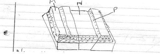
- Use the diagram below to answer the question that follows:-
-
-
- Name the features marked M, N and P (3mks)
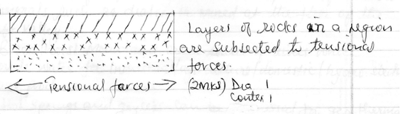
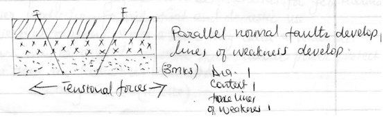
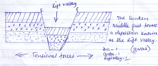
- With well labelled diagrams explain the formation of the Rift valley through tensional forces. (8mks
- Explain five positive effects of faulting. (10mks)
MARKING SCHEME
-
- Name two branches of geography (2mks)
- Physical geography
- Human geography
- Practical geography
- Give three reasons why it is important to study geography. (3mks)
- Geography is a career subject it provides a firm foundation for advanced studies in specialized fields like engineering, remote sensing, urban planning etc.
- Study of geography enables one to acquire basic skills and knowledge which contribute to local, regional and national development.
- Through the study of fieldwork, geography teaches one on how to manage time properly by drawing a time schedule and adhering to it.
- Geography focuses on physical study of the earth. We are therefore able to learn and explain the origin of the earth and the solar system.
- Geography enables the learners to understand and appreciate different environmental influences at work on different societies.
- Geography creates awareness in the people on the significance of management and conservation of the environment.
- Name two branches of geography (2mks)
-
- What is solar insolation? (2mks)
- Solar insolation is the amount of sunshine reaching the surface of the earth.
- Outline three importance of moisture in the atmosphere (3mks)
- Source of precipitation, especially rain.
- Regulating temperature on the earths surface.
- Influencing weather conditions.
- What is solar insolation? (2mks)
-
- State two effects of the rotation of the earth on its axis. (2mks)
- Causes day and night
- It causes deflection of ocean currents/winds.
- It causes falling and rising of the ocean tides.
- It causes different of 1 hour between 150 meridian.
- The local time at manual 60ºW is 11.30 what is the time in Nairobi 37ºE? (3mks)
- Difference in degrees 60º + 37º = 97º
97º x 4 = 388 minutes
1 hour = 60 minutes
Thus 388 ÷ 60 = 6 hours 28 minutes
Nairobi is 6 hours 28 minutes East of manual the time is 11.30 am + 6 hours 28 minutes.
= 17.58 hours or 5: 58 pm
- Difference in degrees 60º + 37º = 97º
- State two effects of the rotation of the earth on its axis. (2mks)
-
- What is an ice sheet ? (2mks)
- An ice sheet is a continuous mass of ice covering a large area /surface.
- State three ways in which ice moves (3mks)
- plastic flowage
- basal slip
- extrusion flow
- What is an ice sheet ? (2mks)
-
- Name the two types of waves experienced in the coastal areas. (2mks)
- Constructive waves
- Destructive waves
- Name three coastal features which result from wave deposition. (3mks)
- Beaches
- Spits
- Mudflats
- Tombolo
- Cuspate forelands
- Dune – belts
- Bars
- Salt marshes
- Name the two types of waves experienced in the coastal areas. (2mks)
- Study the map of Kijabe 1 : 50,000 (sheet 134/3) provided and answer the following questions.
-
- Give the longitudinal extent of the area covered by the map. (2mks)
- 36º 30’ to 36º 45’ E
- Identify the two human made features found at grid square 3301 (2mks)
- plantation
- main track (motorable)
- what is the bearing of the cattle dip at Ewaso kedong valley from grid reference 3195( 2mrks
- 247º +1 or -1
- Give the longitudinal extent of the area covered by the map. (2mks)
-
- calculate the area covered by thicket vegetation in the area covered by the map (3mks)
- full sq = 3
half sq = 15/ 2 = 7.5
3+ 7.5 = 10.5
10.5 km sq.
- full sq = 3
- measure the length of all weather road bound surface C68 and give your answer in km. (2 maks)
- 14.7 + 1 or – 1
- calculate the area covered by thicket vegetation in the area covered by the map (3mks)
-
- Give three evidences showing that the area receives high rainfall (3marks)
- presence of forest at wakagwe
- presence of permanent rivers eg R. kiruiru
- High settlement at the central area
- Citing evidence from the map, identify three economic activities practiced in the area covered by the map (6maks)
- ransport – roads
- lumbering- saw mill gs 3497
- trade – shops gs 3496
- dairy farming – dairy gs 3092
- Quarrying – gs 3493
- Give three evidences showing that the area receives high rainfall (3marks)
- Describe the drainage of the area covered by the map. (5mks)
- The area has rivers such as Ewaso kedong
- R Ewaso kedong has tributaries
- R Ewaso kedong has meanders
- R Ewaso kedong flows southwards
- There are disappearing rivers in the western side of the area covered by the map.
-
-
- State two factors which influence the occurrence of underground water. (2mks)
- Precipitation and evaporation in the area.
- Porosity of rocks
- Permeability of the rocks
- Slope
- Vegetation cover
- Differentiate between a well and spring. (2mks)
- A well is a hole sunk into a permeable rock to reach the water table while a spring is a natural outflow of water from the rocks.
- The diagram below represent an artesian basin. Use it to answer question C (i) (ii)
- Name the parts marked A B, C (3mks)
- A - artesian well
- B - Impermeable rock
- C - Aquifer/permeable rock
- Identify the process marked D (1mk)
- percolation/infiltration
- State three factors which favour the location of an artesian well. (3mks)
- The aquifer must be exposed in an area of sufficient precipitation.
- The aquifer must lie in between two impermeable rocks for it to retain water.
- The aquifer must be of same permeable materials.
- The basin must dip towards a region where the land surface is lower than it is at the exposed end of the previous formation.
- There must be a partial obstruction or total blockage of exit sufficient for the water that comes in higher portion of the aquifer to be replaced under pressure.
- Name the parts marked A B, C (3mks)
-
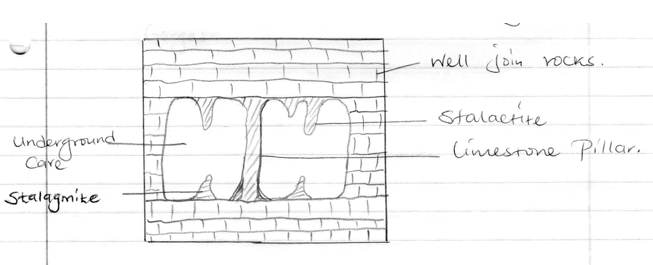
- Apart from stalagmites, name three other underground features formed in limestone areas. (3mks)
- Stalactite
- Limestone pillar
- Underground cave and caverns
- With the aid of a diagram describe how a stalagmite is formed. (6mks)
- Rain water dissolves carbon (iv) oxide in the atmosphere. It forms a weak carbonic acid. The weak acid seeps through the roof of an underground cave. It reacts with the limestone rocks to form calcium hydrogen carbon solution. The solution drips slowly through the roof of the cave to the floor. Each drop which falls on the floor spreads out and evaporates. Residue of sodium carbonate which is in the form of tiny crystals is left on the floor. More crystals form on top of the previous ones. The accumulation of such crystals builds a structure upwards, called a stalagmite.
- Rain water dissolves carbon (iv) oxide in the atmosphere. It forms a weak carbonic acid. The weak acid seeps through the roof of an underground cave. It reacts with the limestone rocks to form calcium hydrogen carbon solution. The solution drips slowly through the roof of the cave to the floor. Each drop which falls on the floor spreads out and evaporates. Residue of sodium carbonate which is in the form of tiny crystals is left on the floor. More crystals form on top of the previous ones. The accumulation of such crystals builds a structure upwards, called a stalagmite.
- Apart from stalagmites, name three other underground features formed in limestone areas. (3mks)
-
- State three reasons why there are few settlement in karst landscapes. (3mks)
- The surface is rugged, thus hindering construction of transport lines.
- The surface in most places has thin soils which would not encourage agriculture.
- The surface is rocky, which is not conducive to settlement.
- The landscape experience inadequate water supply both on the surface and underground.
- The vegetation in most places is poor and would not support livestock rearing.
- Name two surface features found in limestone areas. (2mks)
- Dry, valleys
- Grikes
- Clints
- Swallow holes
- Doline
- Urals
- Poljes
- Gorges
- State three reasons why there are few settlement in karst landscapes. (3mks)
- State two factors which influence the occurrence of underground water. (2mks)
-
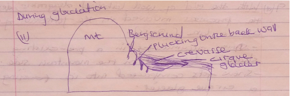
- With the aid of well labelled diagrams describe the processes involved in the formation of a corrie lake. (8mks)
- Snow accumulates in a pre-existing shallow depression on the mountain side.
- Snow gets compacted into ice forming a cirque glacier.
- Alternating freeze thaw or frost action cause rotting and disintegration of rocks a process called nivation which deepens the hollow.
- Abrasion deepens the hollow
- Plucking makes back walls of the depression steeper.
- The result of all these process is the formation f a deep, creep-sided and arm chair shaped depression called a corrie or cirque glacier.
- The cirque glacier has crevasses on the surface and a deep crevasse between the glacier and the back wall called a bergscrund.
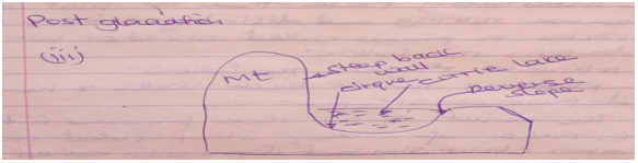
- After the ice melts the melt water on rain water may fill up the depression to form a cirque lake called corrie lake or tarn.
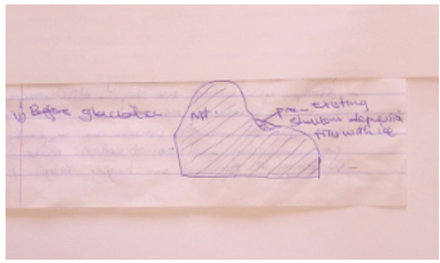
- Before glaciation
- During glaciation
- Post glaciation
- Before glaciation
- Explain four ways in which a glaciated landscape is of significance to human activities. (8mks)
- Warm, glaciated valleys are suitable for farming and settlement
- Glaciated upland features form magnificent sceneries that encourage recreation and sporting activities as well as tourism which generates foreign exchange income.
- Steep, glaciated Mt. slopes discourages human settlements and are hence left for forests growth which are exported for building and construction materials.
- Waterfalls formed on hanging valleys provide suitable sites for H.E.P production which is used for industrial/domestic purposes.
- Corrie lakes/tarns offer suitable areas for fishing.
- U-shaped glacial valleys from natural routeways where roads and railways are constructed.
- Fiord coastlines form deep, well-sheltered natural harbours as well as good fishing grounds thus promoting fishing industry.
- Melting water on glaciated mountains as well as cirques are sources of rivers that provide water for industrial, domestic and agricultural use.
- Glacial till and till plains provide fertile soils for arable farming.
- Ice sheets scour rocks of the surface which may expose minerals making it easy to extract them.
- Outwash plains have sand and gravel which are harvested for use in the building and construction industry.
- Glacial lakes in lowland can be exploited for fishing and transportation.
- Glaciation forms magnificent sceneries such as drumlins and esters which are tourist attraction.
- Glaciated lowlands are generally flat or gently sloping, hence suitable for settlements as well as the development of transport and communication lines.
- Explain three conditions that may lead to glacial deposition in lowlands. (3mks)
- Change in gradient – A relatively flat surface leads to accumulation of large ice sheets which results in melting and deposition of rock materials.
- Changes in temperature or weather changes – A rise in temperature leads to melting of ice and deposition of materials in the ice.
- Seasonal melting due cold periods (winter) followed by a warm period (summer) allows materials in the ice to be deposited.
- Weight of the glacier – A thick and heavy glacier exerts pressure at the bottom causing melting and deposition of materials.
- Stagnation of the ice -This causes a lot of pressure at the base of the valley glaciers leading to melting of the ice. The melt water carries and deposits rock materials.
- Base friction – Friction between moving ice and the valley floor leads to deposition of heavy materials below the ice.
- Amount of moraine in the glacier - A heavy moraine or load leads to deposition of some of the materials.
- Suppose students were to carry out a field study on glaciation on Mt.Kenya
- Name two types of moraines they are likely to study. (2mks)
- Terminal moraine
- Lateral moraine
- Ground moraine
- Medial moraine
- State two problems they are likely to experience during the field study. (2mks)
- Difficult to climb the mountain due to sleep and rugged terrain.
- Inadequate time to climb the mountain
- Heavy rain, strong winds and low temperatures may hinder the study.
- Thick forests or vegetation and swampy conditions may make it difficult to cross/penetrate.
- Dangerous wild animals may attack them
- It is expensive to prepare for this kind of field study.
- It is difficult to conduct pre-visit.
- Low atmospheric pressure or rarefied conditions may lead to breathing problems.
- Poor visibility on the mountain due to low clouds and mist.
- Why was it important for the learners to conduct a pre-visit (2mks)
- To determine appropriate route to be taken
- o farmiliarize themselves with the authority
- Help one identify the appropriate methods to be used
- Helps to identify appropriate equipment to be used
- To identify problems, they are likely to face during the field study
- Name two types of moraines they are likely to study. (2mks)
- With the aid of well labelled diagrams describe the processes involved in the formation of a corrie lake. (8mks)
-
- Describe podzolization as a process of leaching. (2mks)
- This form of leaching occurs in cool climates where the precipitation is higher than evaporation. The soils are sandy and well drained. The soils are heavily leached of all bases including calcium magnesium sodium potassium silica and sequin axides of aluminium and iron. The dissolving is done by the organic acids that are formed when rain percolates through fallen vegetation such as the leaves of coniferous trees.
- State three ways in which mulching helps in soil conservation. (3mks)
- Reduces evaporation of water from the soil.
- Protects the soil from erosion.
- Protects the soil from erosion.
- Increases the humus content of the soil
- Increases the rate of infiltration of water into the soil.
- Explain how the following factors influences the formation of soil.
- Climate (4mks)
- Rainfall provides water which make it possible for rocks to decays/disintegrate to from soil. Rainfall can affect the rate at which some soil forming processes can occur e.g leaching. High temperatures increase the rate of weathering/accelerate the rate of bacterial activities which generates some of the organic matter in the soil. Water ice, and winds erode, transport soil particle in other area leading to the formation of new soil e.g losses)
- Topography (4mks)
- valley bottoms/gentle slopes encourage the formation of deep and fertile soils due to deposition accumulation of materials. Steep slopes encourage erosion of the top layer of soils thus slowing down formation of soil/have thin soils, flat plains/floods plains are saturated with water therefore slows down forming processes. Slope influence arrangement/sequence of soil. Steep slopes are more exposed to the sun/rain which influence weathering of parents rock/soil forms.
- Climate (4mks)
-
- What is soil catena? (2mks)
- Soil catena is the sequence of different soils from the same parent rock on a slope.
- Draw a labelled diagram to show a well – developed soil profile. (3mks)
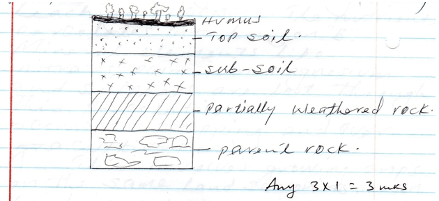
Any 3 x 1 = 3mks
- What is soil catena? (2mks)
- Explain five causes of soil degeneration. (5mks)
- Soil Erosion
- This removes the vegetative cover which protects the soil thus interfering with the soil texture. Wind erosion in arid areas can lead to loss of soil fertility.
- Burning of land
- Clearing forms through slash and burn methods used in shifting cultivation can lead to soil degeneration.
- Mono-corpping/mono culture
- Planting one type of crop repeatedly year after year, on the same plot can lead to soil degeneration.
- Leaching
- Soil nutrients are lost to lower horizons during the leaching processes. The nutrients percolates into horizon B. mineral elements like nitrates potassium magnesium and sulphate are lost through this porcoloation
- Continuous cropping and over cultivation
- This involves growing crops on the same land season to season. Land is not given time to rest. The soils became exhausted because the crops continue sucking the nutrients.
- Change of pH
- Use of fertilizers on land continually may affect the soil pH value.
- Human activities
- Ploughing of steep land down slope increases soil degeneration through soil erosion activities like carrying construction of roads may lead to soil degeneration because they interfere with soil structure.
- Soil Erosion
- Describe podzolization as a process of leaching. (2mks)
-
-
- Faulting is the process whereby crustal rocks fracture/crack due to Tectonic forces. (2mks)
-
- Normal fault
- Reverse fault
- A tear/sheer / slip
- a thrust fault
- An anticlines fault ( 2 mks)
-
- M - Horst mountain
- N - Rift valley
- P - Scarp (3mks)
-
-
- Explain 5 positive effects of faulting (10mks)
- Faulted features e.g rift valley and highest mountains provide unique scenery which promotes tourisms hence a source of foreign exchange.
- Some rift valley lakes are important fishing grounds/mining sites/provide water for irrigation.
- Block/host/mountains relieve high rainfall on the wind ward side which favours agriculture which encourage settlements and growth of forest that provide timber.
- Formation of rift valley led to the exposure of valuable minerals such as diatomite mined at the floor of the rift valley.
- Block/host mountains are a source of rivers which provide water for industrial/agriculture/domestic/hydro – electric power produce.
- Hot springs and geysers can be harnessed for geo – thermal power production for industrial and domestic use.
- Vertical faulting across a river may cause a water fall which may be used to generate hydro – electric power project that used in industries /domestic
Any 5 x 2 = 10mks
-
Join our whatsapp group for latest updates
Tap Here to Download for 50/-
Get on WhatsApp for 50/-
Download Geography P1 Questions and Answers - Nambale Mock Exams 2021/2022.
Tap Here to Download for 50/-
Get on WhatsApp for 50/-
Why download?
- ✔ To read offline at any time.
- ✔ To Print at your convenience
- ✔ Share Easily with Friends / Students