
INSTRUCTIONS TO CANDIDATES:
- This paper consists of two sections A and B.
- Answer ALL questions in Section A.
- In section B answer question 6 (compulsory) and any other two questions.
SECTION A (25 MARKS)
Answer all questions in this section in the answer booklet provided
-
- List two types of minerals (2marks)
- State three conditions that are necessary for the formation of a petroleum reservoir (3marks)
-
- Give three physical conditions that favour coffee growing in Kenyan highlands (3marks)
- Give two economic problems experienced in coffee growing in Kenya. (2marks)
-
- State three characteristics of Jua –Kali industries in Kenya. (3marks)
- State three factors that led to the growth of Iron and Steel industry in the Ruhr Region of Germany (3marks)
-
- What is Bilateral trade? (2marks
- State two factors that hinder trade among members of East African Community (2marks)
-
- Name two main reclamation projects in the Netherlands. (2marks)
- State three reasons for reclaiming swamps in Kenya. (3marks)
SECTION B (75MARKS)
Answer question 6 and any other two questions in the answer booklet provided
- The photograph below shows livestock rearing in Kenya. Use it to answer the questions that follow.
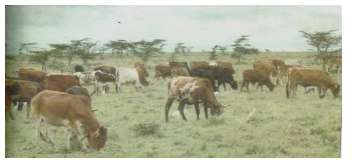
- Identify the type of photograph. (1mark)
- Describe the features shown in the photograph (4marks)
-
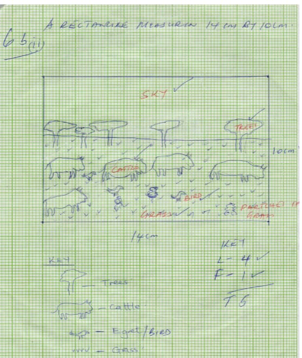
- Draw a rectangle measuring 14cm by 10cm to represent the area covered by the photograph (1mark)
- On the rectangle, sketch and label four features shown on the photograph (5marks)
- Using evidence from the photograph, show two indicators which show that the area is dry (2marks)
-
- Name two areas in Kenya where the photograph could have been taken (2marks)
- Explain how the following factors would improve livestock rearing in Kenya:
- Ranching schemes (2marks)
- Cross breeding (2marks)
- Destocking the animals (2marks)
- State four physical problems facing livestock farmers in Kenya (4marks)
-
-
- Name two provinces in Canada where wheat is grown on a large scale. (2marks)
- State three physical conditions that favour wheat farming in Canada. (3marks)
- Compare wheat farming in Kenya and Canada under the following sub-headings
- Research (2marks)
- government policy (2marks)
- transport (2marks)
- Explain four problems that affect wheat farming in Canada. (8marks)
- Your geography class intends to carry out a field study on wheat harvesting in a farm
- State two reasons for preparing a working schedule (2marks)
- Outline two problems that face wheat harvesting you are likely to find out. (2marks)
- Suppose during the field study you used the interview method to collect data. State two limitations of the method. (2marks)
-
-
-
- Identify four types of fishing (4marks)
- Apart from drifting, name three other modern methods of fishing. (3marks)
- Describe how drifting method of fishing is carried out. (6marks)
- Explain four factors favoring fishing in the North East Atlantic fishing ground. (8marks)
- Give four reasons why fish farming is encouraged in Kenya (4marks)
-
-
-
- List three Jua Kali Industries which are located in rural areas of Kenya. (3marks)
- Suggest three ways in which the Kenya government can promote the development of the Jua Kali Industries. (3 marks)
- Explain three problems arising from industrialization. (6 marks)
- Explain four factors which influenced the location of iron and steel industry in the Ruhr region of Germany in the 19th century. (8 marks)
- Students of a school in Mombasa County went for a field study at the oil refinery in Mombasa.
- List two methods that they used to record data. (2 marks)
- Give three problems that they might have faced during the study. (3 marks)
-
-
-
- Distinguish between management and Conservation of Environment. (2marks)
- Apart from flooding, give two other forms of environmental hazards experienced in Kenya. (2marks)
-
- Identify three districts that are prone to frequent flooding. (3marks)
- Explain four measures that are taken to control flooding in Kenya. (8marks)
- State four problems resulting from flooding. (4marks)
- Explain three reasons why it is necessary to manage and conserve the environment. (6marks)
-

MARKING SCHEME
-
- list two types of minerals (2marks)
- Metallic minerals
- Non – metallic minerals
- Fossil fuels and energy minerals (2 x 1 = 2mks)
- Metallic minerals
- State three conditions that are necessary for the formation of a petroleum reservoir
- Deposition / presence of remains of flora and fauna over a long period of time / fossils.
- Presence of non- porous rocks underneath the deposits of the flora and fauna.
- Deposition of other layers of the rocks over the remains of flora and fauna.
- Compression of the remains of flora and fauna due to folding over the layers of rocks.
- Presence of porous rocks (3 x 1 = 3mks )
- Deposition / presence of remains of flora and fauna over a long period of time / fossils.
- list two types of minerals (2marks)
-
- Give three physical conditions that favour coffee growing in Kenyan highlands
- Cool climate / cool conditions / temperature ranging from 14 – 260c.
- High rainfall / 1000mm – 2030 mm per year
- Well distributed rainfall throughout the year.
- Gently sloping landscaping / 1000 – 2300m above level.
- Deep, well drained, volcanic soils. (3 x 1 = 3mks)
- Cool climate / cool conditions / temperature ranging from 14 – 260c.
- Give two economic problems experienced in coffee growing in Kenya.
- Fluctuation of prices in the world market.
- Competition from other land uses / crops
- Inadequate labor during harvesting/ weeding.
- Expensive prices of inputs / fertilizers / pesticides.
- Competition from other beverages.
- Mismanagement of coffee co-operatives.
- Delayed payments / low payments.
- Poor roads. ( 2 x 1 = 2 mks)
- Fluctuation of prices in the world market.
- Give three physical conditions that favour coffee growing in Kenyan highlands
-
- Three characteristics of Jua –Kali industries in Kenya.
- It requires little capital to set up and so easy to start.
- Can be organized by one person or two.
- Site flexibility
- Use relatively little and simple raw materials.
- Use local resources as well as local skilled labor.
- Use of simple tools.
- Products are sold locally and internationally thus earning income to the producers and foreign exchange to the country ( 3 x 1= 3mks)
- It requires little capital to set up and so easy to start.
- State three factors that led to the growth of Iron and Steel industry in the Ruhr Region of Germany
- Availability of coal / iron ore / limestone / raw materials within the region.
- Cheap water transport on river Rhine / canal.
- Availability of capital from rich merchants / krupp family.
- Abundant sources of power such as coal / HEP
- Ready market from central/ western Europe / internal market.
- Availability of skilled labor from the local population.
- Industrial interdependence / industrial inertia.
- Availability of water from river Rhine and its tributes such as Lippe / Wupper / Ruhr.( 3 x 1 = 3mks)
- Three characteristics of Jua –Kali industries in Kenya.
-
- What is bilateral trade?
- This involves the exchange of goods and services between two countries. ( 1 x 2 = 2mks)
- State two factors that hinder trade among members of East African Community (2mark
- Membership to different trading blocs by different countries.
- Lack of common currency.
- Poor transport network / under developed transport network.
- Restriction of movement of people and goods / high taxation
- Production of similar goods
- Political instability
- Political differences. (2 x 1=2mks)
- Membership to different trading blocs by different countries.
- What is bilateral trade?
- Name two main reclamation projects in the Netherlands. (2marks)
- The zuider zee project.
- The delta plan project.
- State three reasons for reclaiming swamps in Kenya. (3marks)
- To free area from pest/water borne diseases.
- To reduce flooding and associated effects.
- To acquire agricultural land with profitable farming/settlement.
- To develop the remote areas with social amenities.
- Name two main reclamation projects in the Netherlands. (2marks)
-
-
- ground general view √
-
- On the foreground there are patches of long grass and some continuous grass/ some animals are white birds.
- In the middle ground there are cattle grazing and scattered acacia tree
- The sky is clear/blue at the back ground. 4 x 1=4mks
-
-
-
- Cloudless sky
- Patches of dry/brown grass
- Presence of scatter acacia trees
- Presence of dwarft trees (3 x 1 =3mks)
-
-
-
- Athi Kapithi plan
- Wet ares of masai land
- Kajiado
- Central rift valley
- Narok
-
- Ranches schemes
- It enhances scientific rearing of animals i.e. voluntary services hence high quality animals/paddocks enhance enough grass plus disease and pest control this animals develop faster. ( 2x2 = 2mks)
- Cross breeding
- It result to high quality breed that is resistant to diseases and matures faster hence improves quality of livestock products ( 2x1 = 2mks)
- Destocking
- It would reduce the number of stocks to allow the pasture to grow hence enough grass for the animals enables holding capacity (2x1 = (2mks)
- Ranches schemes
-
-
- Livestock diseases i.e. foot and mouth disease lowers the quality of the cattle product.
- Rest i.e. tick/tsetse fly causes disease hence the animals die
- Adverse weather conditions i.e. drought results the shortage of water√ /and pasture hence animals do migrate from place to place in search of pasture and water, hence some die due to long distance.
- Low quality breed that takes long to mature and produces less cattle products i.e. milk
- Attack from wild animals i.e. Lion, hyena killing the livestock
- Cattle rusterless results too many cattle stolen. ( 5 x 1 = 5mks)
-
-
-
-
- Alberta
- Manitoba
- Saskatchewan
-
- Availability of extensive undulating land
- Well drained soils /deep soils.
- Moderate temperature/ averaging 150c/ warm climate or conditions
- Rainfall of about 660mm/ moderate rainfall
- Presence of dark brown chernozems/ prairies soil/ black earth
- Sunny summer conditions for harvesting.
-
-
- In Kenya, little research is being undertaken on wheat farming while in Canada there is advance Research on wheat farming which produces high yielding seeds/ control of pests and diseases.
- In Kenya, there is no government policy on subsidence/ in centres to wheat farmers while in Canada the government gives subsidies to the farmers in case of crop failure.
- In Kenya, there is poor road/ railway network in growing areas while in Canada there is water/ road/ railway network in wheat growing areas.
-
- Fluctuation in world prices of wheat has led to farmers being uncertain about their earnings hence turning to growing of crops with better earnings.
- The soils have become exhausted due to long use / leading to lower yields/ lower quality yields.
- Occurrence of drought/ hail/ prolonged winters have destroyed wheat drops/ leading to lower yields/ lower quality.
- Due to pests and diseases the farmers have to spray the crop with chemicals hence increase in cost of production and lowering the profit margin
- Canada faces competition from other wheat producing countries which has reduced the market for her produce.
- The frozen waterways in winter hinder accessibility to the market.
-
-
- A work schedules ensures all the intended activities are captured.
- It helps in time management
- It helps to monitor the field work while still in progress.
- It enables the research group to remain within the scope or the study.
-
- Shortage of harvesting machinery/ combine harvester
- Rainy weather conditions hinder the movement of combine harvester.
- High cost of labor/ hiring machinery/ inadequate funds to hire
- Spillage of wheat during harvesting
- Breakdown of machinery.
-
- The respondents may give inaccurate information
- It is time consuming
- Some respondents may be unwilling/ hostile
- Language barrier may arise/ illiteracy
-
-
-
-
- Identify four types of fishing (4marks)
- pelagic fishing
- Demersal fishing
- Inshore fishing
- Fresh water fishing 4 x 1 = 4mks
- Apart from drifting, name three other modern methods of fishing. (3marks)
- Trawling
- Purse – seining
- Lining/ line/ angling/ long line 3x 1 =3mks
- Identify four types of fishing (4marks)
- Describe how drifting method of fishing is carried out. (6marks)
- The method is used for harvesting pelagic fish
- The net hangs vertically in the sea/ ocean water like a lawn tennis net.
- The net is attached to a ship/ drifter
- The upper side of the net has floats and the lower side has weights which make the net hang vertically
- As a shoal of fish tries to swim through the net, they are entangled by their gills and fins and so remain trapped in the net/ mesh.
- It is dragged at the surface or near the surface by a motorized vessel called drifter
- After sufficient fish is caught, the net is hauled into the ship and catch is gathered, then the net returned into the water for the next catch. 6 x 1= 6mks
- Explain four factors favoring fishing in the North East Atlantic fishing ground. (8marks)
- The region experiences low temperatures that are favorable for the survival of fish/ natural preservation of fish.
- The numerous fords/ indented coasts form inlets which provide shelters for the spawning of fish and also sites for building fishing ports.
- The ruggedness of the landscape limits agriculture activities this makes fish appropriate economic activity.
- The prevailing warm Atlantic drift raises the temperature thus making the area ice free throughout the year.
- The area has a large shallow continental shelf which allows penetration of sunlight to ocean bed hence encouraging the growth of plantation used as food for fish hence plant of fish.
- The dense population in the region provides a wide market and cheap labour for fish fishing industry.
- The advanced technology has made it possible to manufacture fishing vessels for both inshore and deep sea fishing thus making it possible for fishermen to carry out large scale fishing.
- The numerous rivers which drain their water into the North Sea bring a lot of mineral within the continental shell/ a lot of plankton for fish to feed on hence presence of a lot fish species.
4 x 2 = 8mks
- Give four reasons why fish farming is encouraged in Kenya (4marks)
- It allows better and maximum use of land and water resources.
- To meet demand for food rich in proteins
- To create employment opportunities/ earn income
- To assist in conservation of rare species that might face extinction.
- It is free from international disputes
- Leads to the development of more related fish industries.
- To assist in conservation of rare species that might face extinction.
-
-
-
- List three Jua Kali Industries which are located in rural areas of Kenya. (2 marks)
- Pottery industries.
- Wood carving.
- Soap stone carving.
- Waving industries.
- Sheet metal work.
- Wielding/steel work.
- Basketry.
- Mat making.
- Shoe making.
- Suggest three ways in which the Kenya government can promote the development of the Jua Kali Industries. (3 marks)
- By providing financial support to artisan.
- By building better sheds for the artisan.
- By carrying out research to produce better products.
- By intensifying rural electrification to provide adequate power for the artisan.
- By encouraging the formation of cooperatives among the artisans.
- By encouraging Kenyans to buy from jua kali artisans.
- List three Jua Kali Industries which are located in rural areas of Kenya. (2 marks)
- Explain three problems arising from industrialisation. (3 marks)
- Industrialization has led to rural-urban migration which has increased the urban population leading to congestion/shortages of houses/increase in crime.
- Some industries emit toxic gases which are harmful to people/wildlife.
- Industries effluent pollutes water sources making the water unfit for human/ animal use.
- Fumes from chemical industries collode metallic roofs of buildings hence destroying them.
- Congestion of unfrastructure and social services in the industrial areas has led to the degradation of land.
- Some industries have led to the displacement of people thus disrupting their social and economic life.
- Explain four factors which influenced the location of iron and steel industry in the Ruhr region of Germany in the 19th century. (8 marks)
- Availability of coal-iron ore as well as limestone from the Rhine – Valley provided raw materials needed in the industry.
- River Rhine/Ruhr/Lippe/Wupper/Escher provided water required for cooling machines in the industry/industrial use.
- The region is served by navigable rivers of River Rhine/Ruhr/cheap transport for the bulky raw material/materials and finished products.
- Cheap water transports for the bulky raw materials and is required for the cooling machines in the industry.
- Coal from the Ruhr region/imported petroleum provided power required in the industry.
- The local population had acquired skills on iron working/availability of local skilled labour and this formed the foundation of iron and steel industry.
- Presence of rich companies of Ruhr Khlet Krupp which provided capital for the development of the industries.
- The dense and affluent population in (Central and Western) Europe/Germany provided ready market for iron and steel.
- Field work on industries.Students of a school in Mombasa County went for a field study at the oil refinery in Mombasa.
- List two methods that they used to record data. (2 marks)
- Note taking.
- Filling questionnaires.
- Taper/video recording.
- Sketching diagrams/maps. (Any 2 x 1 = 2mks)
- Give three problems that they might have faced during the study. (3 marks)
- Students might have got injured/
- Pollution from the industry – noise/gases
- Noise pollution could have interfered.
- With bearing.
- Bad weather too hot for the study. (Any 3 x 1 = 3mks)
- List two methods that they used to record data. (2 marks)
-
-
-
- Distinguish between management and conservation of environment.
- Environmental management is the planning and implantation of the plan to ensure effective and proper utilization of the available resources in the environment while environmental conservation involves the protection, preservation and proper utilization of resources in the environment. So as to continue benefiting the present generation. (1x2 = 2mks)
- Apart from floods, give two other form of environmental hazards experienced in Kenya.
- Earthquakes
- Lightening.
- Forest fires.
- Soil erosion.
- Landslides.
- Drought.
- Pests and diseases. (any 2x1 = 2mks)
- Distinguish between management and conservation of environment.
-
- Identify three districts that are prone to frequent flooding.
- Tana River
- Garissa.
- Budalangi.
- Ahero. (any 3x1 = 3mks)
- Explain four measures that are taken to control flooding in Kenya.
- Building dams across rivers to hold excessive water and reduce massive destruction.
- Building dykes and embankments on river banks to hold Back River water.
- Deepening of river channels to accommodate large volume of water to the main channel.
- Executing people form flood prone areas and using those areas for other economic purpose.
- Starting forestation and reforestation programmes in upper course of the river to reduce water speed.(Any 4x2 = 8mks)
- State four problems resulting from flooding.
- Loss of lives and property.
- Destruction of habitats e.g. spawning grounds for fish.
- Interferes with drainage in urban centers.
- High financial losses when carrying out repair work.
- Displacement of people thus disrupting day to day activities.
- Pest and diseases brought about by stagnant water. (any 4x1 = 4mks)
- Identify three districts that are prone to frequent flooding.
- Explain three reasons why it is necessary to manage and conserve the environment.
- To protect the water catchments areas so that the rivers and streams do not dry up.
- The environment should be managed and conserved for posterity.
- To prevent desertification so that water sources do not dry up.
- The natural vegetation provides herbs for medicine.
- The natural resources are exploited to get income.
- To protect endangered species which serve as sits for recreation? (any 3x2= 6mks)
-
Join our whatsapp group for latest updates
Tap Here to Download for 50/-
Get on WhatsApp for 50/-
Download Geography Paper 2 Questions and Answers - Pavement Mock Exams 2021/2022.
Tap Here to Download for 50/-
Get on WhatsApp for 50/-
Why download?
- ✔ To read offline at any time.
- ✔ To Print at your convenience
- ✔ Share Easily with Friends / Students