A small field was surveyed and the measurements recorded in a surveyor’s field book as in the table below:
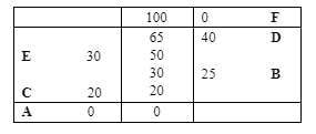
- Using a scale of 1cm to 10m make an accurate drawing of the map of the field.
- Find the area of the field.
- Assuming that the baseline in (1) runs in a northern direction give the position of D relative to A using bearing and distance.