
Instructions to Candidates:
- This paper has two sections A and B.
- Answer all questions in section A.
- Answer question 6 and any other two questions from section B.
SECTION A (25 Marks)
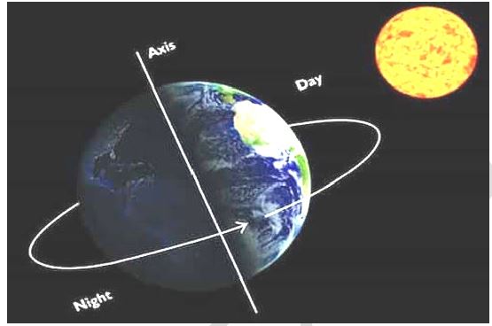
- The diagram below represents movement of the earth. Use it to answer the following questions.
-
- Identify the type of movement (1mk)
- Describe how the above movement causes day and night (2mks)
- State three proofs that the shape of the earth is spherical (3mks)
-
- The diagram below shows a simple hygrometer. Use it to answer questions.
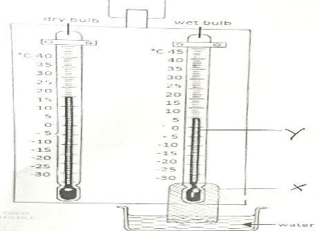
- Identify the parts labelled X and Y. (2mks)
- Outline the steps followed when measuring humidity using hygrometer (3mks)
-
- Differentiate between intensity of an earthquake and magnitude of an earthquake (2mks)
- Name three major zones of the world. (3mks)
-
- Name two lakes in East Africa which were formed as a result of crustal down warping (2mks)
- State three reasons why some lakes are salty. (3mks)
-
- List two types of dunes (2mks)
- Identify two processes through which wind transports materials in arid areas. (2mks)
SECTION B. (75 Marks)
Answer question 6 (compulsory) and any other two questions from this section.
- Study the map of Kisumu East (1:50,000), sheet 116/2 provided and answer the following questions.
-
- Convert the linear scale of the map into a statement scale. (2mks)
- Identify two relief features found in the North Eastern part of the area covered by the map (2mks)
- Using latitudes and longitudes, locate the position of the North Western corner of the map (2mks)
- What is the bearing of trigonometric station 115SKP21 from the air photo principal point 03 next to Obumbu School. (2mks)
-
- The rectangle below represents the area in the map extract bounded by eastings 00 and 05 and Northing 83 and 88.
-
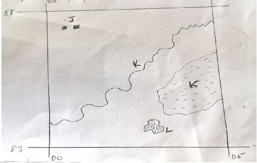
- Identify and name the features marked J, K, L and M. (4mks)
- State three problems likely to be encountered during the construction of roads in the area covered by the map (3mks)
- Describe the long profile of River Ombeyi (4mks)
- Citing evidence from the map, give three social functions of Kisumu town. (6mks)
-
-
- Differentiate between the process of formation of plutonic and volcanic rocks. (2mks)
-
- For each of the following sedimentary rocks, name the resultant rocks that forms after metamorphism.
- Sand stone (1mk)
- Limestone (1mk)
- Clay (1mk)
- Describe the process of formation of the following type of sedimentary rocks.
- Mechanically formed (4mks)
- Organically formed (4mks)
- For each of the following sedimentary rocks, name the resultant rocks that forms after metamorphism.
- Explain the significance of rocks to the economy of Kenya under the following
- Tourism
- Energy
- Water
- You are planning to carry out a field study on rocks within the local enevironment.
- List three methods you would use to record data. (3mks)
- State three problems you are likely to encounter (3mks)
-
-
- Apart from fold mountains , name three other features resulting from folding (3mks)
- In which countries are the following fold mountains found.
- Andes
- Cape ranges
- Atlas
- The map below shows the location of some fold mountain ranges.
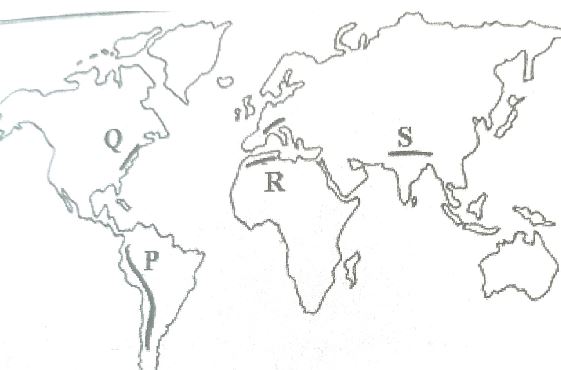
- Identify the orogenies during which the the mountains marked P, Q, R, S were formed. (4mks)
- With the aid of a well labelled diagram, describe how the fold mountains were formed (10mks)
- State five significance of fold mountains to human activities(5mks)
-
- The map below shows some vegetation regions of the world. Use it to answer questions a to c.
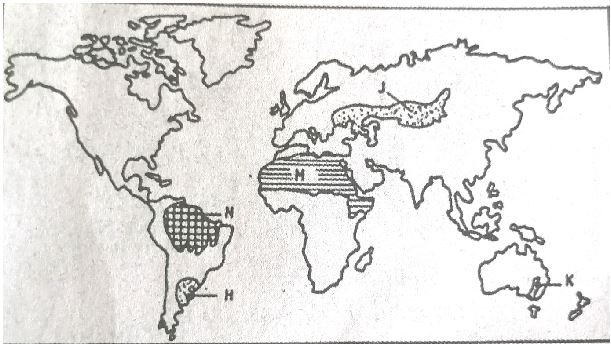
- Name the temperate grasslands marked H,J and K. (3mks)
- Describe the characteristics of the natural vegetation found in the shaded area marked N. (6mks)
-
- Explain four ways in which the vegetation found in the area marked M adapts to the environmental conditions of the region (8mks)
- Give two reasons why Tundra region has scattered vegetation (2mks)
- You are required to carry out field study of the vegetation within the local environment.
- Apart from identifying the different types of plants, state three other activities you will carry out during the field study. (3mks)
- How will you identify the different types of plants (3mks)
-
-
- Differentiate between a barrier reef and a fringing reef (2mks)
- The diagram below represents some coastal features . Name the features marked P, Q,R (3mks)
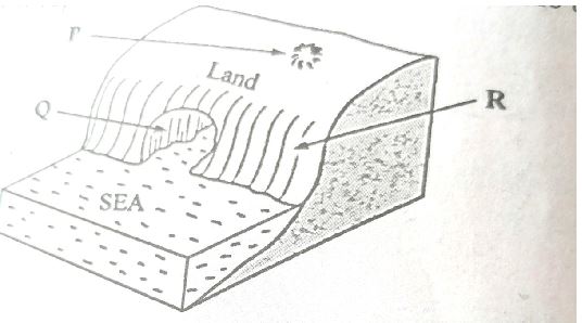
- State two conditions necessary for the formation of a beach (2mks)
- With the aid of a well labelled diagram, describe the process through which a stack is formed (8mks)
-
- State four conditions that favour the growth of corals. (4mks)
- Explain three ways in which coral contributes to the economic development of Kenya (6mks)
-
MARKING SCHEME
SECTION A
- The diagram below represents movement of the earth. Use it to answer the following questions.
-
- Identify the type of movement (1mk)
- Rotation
- Describe how the above movement causes day and night (2mks)
- During the rotation of the earth, the half side of the earth, which faces the sun, receives sunlight hence day, while the half side that faces away from the sun is in darkness hence night.
- State three proofs that the shape of the earth is spherical (3mks)
- The gradual appearance of the ship approaching the shore.
- Circumnavigation
- The different times during which the sun rises and sets in different parts of the world.
- The circular shadow of the earth cast on the moon during the lunar eclipse.
- The horizon of the earth appear curved when observed from a raised ground.
- Satellite photographs taken at high altitude shows that the earth is spherical.
- Identify the type of movement (1mk)
-
- The diagram below shows a simple hygrometer. Use it to answer questions.
- Identify the parts labelled X and Y.
- X-Muslin
- Y-Mercury (2mks)
- Outline the steps followed when measuring humidity using hygrometer (3mks)
- Read and record the temperature of dry bulb thermometer.
- Read and record the temperature of wet bulb thermometer
- Calculate the difference in temperature of wet and dry bulb thermometer
- Use convection scale to determine humidity
- Identify the parts labelled X and Y.
-
- Differentiate between intensity of an earthquake and magnitude of an earthquake (2mks)
- Intensity measures how strong and hard the earthquake shakes the ground while magnitude is the measure of the amount of energy released by an earthquake.
- Name three major zones of the world (3mks)
- The great rift valley
- The Mediterranean-Himalayan belt
- The mid-Atlantic Ocean belt
- Differentiate between intensity of an earthquake and magnitude of an earthquake (2mks)
-
- Name two lakes in East Africa which were formed as a result of crustal downwarpping (2mks)
- Lake Victoria
- Lake Kyoga
- Lake Kakira
- Lake Nikivali
- State three reasons why some lakes are salty (3mks)
- Some lie in areas of high temperatures leading to high evaporation rate
- The lake bed is made of salty bedrock
- The lakes have no outlets
- The lakes may be fed by underground water streams, which have passed through rocks bearing salts
- Name two lakes in East Africa which were formed as a result of crustal downwarpping (2mks)
-
- List two types of dunes (2mks)
- Barchans
- Seif dunes/ longitudes/linear
- Transverse dunes/wave dunes
- Star dunes
- Draas
- Identify two processes through which wind transports materials in arid areas (2mks)
- Suspension
- Saltation
- Surface creep/traction
SECTION B.
Answer question 6 (compulsory) and any other two questions from this section.
- List two types of dunes (2mks)
- Study the map of Kisumu East (1:50,000), sheet 116/2 provided and answer the following questions.
-
- Convert the linear scale of the map into a statement scale. (2mks)
2/2cm rep1/2km 1 cm rep 0.5km - Identify two relief features found in the North Eastern part of the area covered by the map (2mks)
- Escarpment
- Rock outcrop
- Steep slope
- River valleys
- Ridges
- Hills
- Using latitudes and longitudes, locate the position of the North Western corner of the map (2mks)
-(0°00, 34°45'E) - What is the bearing of trigonometric station 115SKP21 from the air photo principal point 03 next to Obumbu school. (2mks) -Bearing = 220°±1(219219°,220°,221°
- Convert the linear scale of the map into a statement scale. (2mks)
-
- The rectangle below represents the area in the map extract bounded by eastings 00 and 05 and Northing 83 and 88.
Identify and name the features marked J, K, L and M.- J - Nyalonya School
- K - Seasonal swamp
- L - Rabuor market
- M - Mayenya river (4mks)
- State three problems likely to be encountered during the construction of roads in the area covered by the map (3mks)
- Rugged landscape /steep slope/ridges/escarpment/hills
- Many rivers /River valley may lead to construction of many bridges/culverts increasing cost of construction.
- Presence of swamps may lead to destruction of roads increasing costs of construction.
- High density of settlement may lead to high cost of compensation increasing the cost.
- The rectangle below represents the area in the map extract bounded by eastings 00 and 05 and Northing 83 and 88.
- Describe the long profile of River Ombeyi (4mks)
- River ombeyi flows southwards
- River Ombeyi has meanders in upper course
- River Ombeyi flows through a swamp
- River Ombeyi is a permanent river
- River Ombeyi and its tributaries form dentritic pattern
- Citing evidence from the map, give three social functions of Kisumu town. (6mks)
Social function evidence Education centre Health centreRecreational centreAdministrative centreBurial centreReligious centreSchoolsHospitalsStadiumPrisonD.O, police stationCemeterymission
-
-
- Differentiate between the process of formation of plutonic and volcanic rocks. (2mks)
- Plutonic rocks form from magma which cools slowly and solidifies within the cracks and chambers in the earths crust while volcanic rocks forming from lava that cools fast and solidifies out of the earths surface.
-
- For each of the following sedimentary rocks, name the resultant rocks that forms after metamorphism.
- Sand stone - Quartzite /slate (1mk)
- Limestone - marble (1mk)
- Clay - slate/schist (1mk)
- Describe the process of formation of the following type of sedimentary rocks.
- Mechanically formed (4mks)
- Sediments used to form the rocks are derived from weathering of existing rocks
- The weathered materials are transported by wind/ice/water
- The weathered materials are deposited in layers on land or sea
- They are then compacted and cemented into sedimentary rocks
- Organically formed (4mks)
- These are rocks formed from remains of dead plants and animals/fossils.
- These remains accumulate in the oceans/land in layers
- The materials are deposited in layers
- The accumulated materials are compressed / compacted and cemented into sedimentary rocks.
- Mechanically formed (4mks)
- For each of the following sedimentary rocks, name the resultant rocks that forms after metamorphism.
- Explain the significance of rocks to the economy of Kenya under the following
- Tourism- some rocks form unique features that attract tourists earning country foreign exchange
- Energy –some sedimentary rocks contain fossil fuel which are sources of energy for domestic /industrial use
- Water-some rocks act as storage of water which can be used for industrial , domestic and agricultural use.
- You are planning to carry out a field study on rocks within the local enevironment.
- List three methods you would use to record data. (3mks)
- Photographing / video recording
- Labelling of samples
- Note taking
- Filling in questionnaires
- Drawing diagrams
- Tape recording
- State three problems you are likely to encounter (3mks)
- Accidents may occur
- Inaccessibility of some areas with rocks
- Fatique due to difficult terrain
- Attack by wild animals/snake bites
- High temperatures /abrupt rain
- Difficulty in breaking some rocks
- List three methods you would use to record data. (3mks)
- Differentiate between the process of formation of plutonic and volcanic rocks. (2mks)
-
-
- Apart from fold mountains , name three other features resulting from folding (3mks)
- Rolling plains
- Ridges
- Synclinal valley
- Intermontane basins
- Intermontane plateaus
- In which countries are the following fold mountains found.
- Andes- venezuela, Ecuador, Colombia, Peru, Bolivia, Chile, Argentina
- Cape ranges- South Africa
- Atlas-Morocco, Algeria, Tunisia
- Apart from fold mountains , name three other features resulting from folding (3mks)
- The map below shows the location of some fold mountain ranges.
- Identify the orogenies during which the the mountains marked P, Q, R, S were formed. (4mks)
- P - Alpine orogeny
- Q - Hercynian orogeny
- R - Alpine orogeny
- S - Alpine orogeny
- Identify the orogenies during which the the mountains marked P, Q, R, S were formed. (4mks)
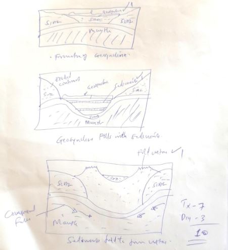
- With the aid of a well labelled diagram, describe how the fold mountains were formed (10mks)
- Extensive shallow depression called geosyncline develop on the surface of the earth
- Prolonged and extensive erosion occurs on the surrounding higher grounds
- Sediments are developed in the geosyncline forming thick layers
- The weight of sediments causes subsidence of the geosyncline leading to accumulation of more sediments to great thickness.
- Further subsidence of the geosyncline triggers off compressional forces which causes sediments to fold.
- The folded layers of sediments in the geosyncline are thrust upwards to form fold mountains.
- State five significance of fold mountains to human activities (5mks)
- Fold mountains are sources of rivers that produce water for generation of HEP/domestic use/industrial use
- Fold mountains are often forested and provide timber for building and construction.
- Fold mountains are tourist attractions.
- Windward slope of the mountain receive high rainfall which promote agriculture.
- Some fold mountains may act as barrier to transport and communication.
-
- The map below shows some vegetation regions of the world. Use it to answer questions a to c.
- Name the temperate grasslands marked H,J and K. (3mks)
- H - pampas of Argentina
- J - Steppes of Russia
- K- of Australia
- Describe the characteristics of the natural vegetation found in the shaded area marked N (6mks)
- The trees have broad leaves
- Some trees have buttress roots
- The forest has little undergrowth
- The forest has canopies
- Some trees shed their leaves
- The forest have climbers
-
- Explain four ways in which the vegetation found in the area marked M adapts to the environmental conditions of the region (8mks)
- Some plants have thick /fleshy /succulent leaves to enable them store water
- Some plants have no leaves /have thin spiky /waxy/needle-like leaves to reduce water loss
- Some plants have shiny surfaces to reflect light
- Some plants have long tap[ root to draw water
- Some plants shed off leaves during dry seasons to reduce water losss.
- Give two reasons why Tundra region has scattered vegetation (2mks)
- The ground is frozen most time of the year
- The area has thin soils
- Some parts are poorly drained
- The area has very short growing/seasonal/short summers/warm seasons
- Explain four ways in which the vegetation found in the area marked M adapts to the environmental conditions of the region (8mks)
- You are required to carry out field study of the vegetation within the local environment.
- Apart from identifying the different types of plants, state three other activities you will carry out during the field study. (3mks)
- Collect samples of plants
- Draw sketches
- Count plants
- Measure distances
- How will you identify the different types of plants (3mks)
- By their appearance
- By their colour
- By their leaves
- By their nature of fruits, texture, system of their leaves, nature of their barks
- Apart from identifying the different types of plants, state three other activities you will carry out during the field study. (3mks)
- Name the temperate grasslands marked H,J and K. (3mks)
-
-
- Differentiate between a barrier reef and a fringing reef (2mks)
- A barrier reef is formed along distance away from the shore and separated from the shore by a wide deep lagoon whereas a fringing reef is closer to the shore and separated from the shore by a shallow lagoon
- The diagram below represents some coastal features . Name the features marked PQR (3mks)
- P-Blow hole
- Q-Cave
- R-Cliff
- State two conditions necessary for the formation of a beach (2mks)
- A gently sloping land at the sea shore
- The shore should be shallow
- Strong swash/constructive waves /weak backwash
- Deposition should exceed erosion
- Wave should carry a lot of materials to be deposited
- Differentiate between a barrier reef and a fringing reef (2mks)
- With the aid of a well labelled diagram, describe the processs through which a stack is formed (8mks)
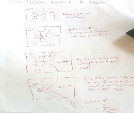
- Waves attack both sides of headland of right angles
- The waves erode through abrasion and hydraulic actions forming caves on both sides of the headland.
- Continued wave erosion and weathering leads to elongation of the caves into headland
- Eventually the caves merge/join leading to formation of an arch
- The roof of the arch collapses leading to isolation of the headland on seaward side
-
- State four conditions that favour the growth of corals. (4mks)
- Warm waters
- Saline waters
- Well oxygenated waters
- Clear waters free from silt
- Shallow waters
- Explain three ways in which coral contributes to the economic development of Kenya (6mks)
- Corals features attract tourists which bring foreign exchange into the economy
- Coral stones are attracted and sold as ornaments
- Coral reefs promote limestone which is used as raw materials for cement making
- Coral rocks provide stones, which are in the building industry
- State four conditions that favour the growth of corals. (4mks)
-
Join our whatsapp group for latest updates
Tap Here to Download for 50/-
Get on WhatsApp for 50/-
Download Geography Paper 1 Questions and Answers - BSJE Mock Exams 2023.
Tap Here to Download for 50/-
Get on WhatsApp for 50/-
Why download?
- ✔ To read offline at any time.
- ✔ To Print at your convenience
- ✔ Share Easily with Friends / Students