
Instructions to candidates
- This paper has two sections: A and B
- Answer all the questions in section A
- Answer question 6 and any other two questions from section B
- All answers must be written in the answer booklet provided
SECTION A
Answer ALL the questions in this section
-
- Name two branches of Geography (2 marks)
- Give three reasons why it is important to study geography in secondary schools (3 marks)
-
- What is due point (2 marks)
- State three factors that influence atmospheric pressure (3 marks)
-
- Give three human causes of earthquakes. (3 marks)
- Give two major earthquake zones of the world (2 marks)
-
- Identify two sources of underground water. (2 marks)
- State three conditions that favour the formation of artesian well. (3 marks)
-
- Define the term ice berg (2 marks)
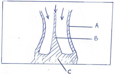
- The diagram below shows types of moraines. Identify the moraines labeled A, B and C. (3 marks)
SECTION B
Answer Question 6 and any other two questions from this section
- Study the map of Kisum East 1:50,000 Sheet 116/2) provided and answer the following questions.
Use the marginal information-
- Give the longitudinal extent of the area covered by the map (1 mark)
- What is the vertical interval of the area covered by the map (1 mark)
- Give the magnetic declination of the map (1 mark)
-
- Name three human made features in the grid square 0193 (3 marks)
- Calculate the area of Kisumu town, Give your answer in kilometer squire. (2 narks)
- Describe the relief of the area covered by the map. (4 marks)
-
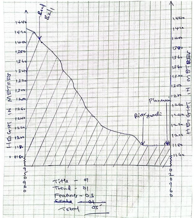
- Draw a cross-section along Northing 96 between Easting 95 and 02 (2 marks)
(Use scale 1cm represents 20 metes)
On the cross-section show: -- Bound surface road (1 mark)
- River Awach (1 mark)
- Plantation (1 mark)
- Calculate V.E (2 marks)
- Citing evidence, give three social functions of Kisumu town. (6 marks)
- Draw a cross-section along Northing 96 between Easting 95 and 02 (2 marks)
-
-
-
- What is a mineral (2 marks)
- Describe the following characteristics of minerals
- Lusture (2 marks)
- Colour (2 marks)
- Density (2 marks)
- Briefly describe three types of sedimentary rocks. (6 marks)
- Students of Namunyweda carried out a field study on rocks around their school.
- State a reason why they carried
- A hammer (1 mark)
- Polythene bag (1 mark)
- Litmus paper (1 mark)
- State four follow-up activities they engaged in 4 marks)
- State a reason why they carried
- Explain the significance of rocks under the following headings
- Tourism (2 marks)
- Water (2 marks)
-
-
-
- State the two causes of waves in the oceans. (2 marks)
- The diagram below shows parts of a wave.
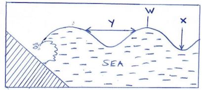
Name the parts marked W, X and Y. (3 marks)
-
- Name three types of submerged coasts. (3 marks)
- Explain three processes involved in marine erosion. (3 marks)
-
- Using well labeled diagrams, explain how the following coastal features are formed.
- Stacks (4 marks)
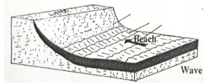
- Beaches (4 marks)
- Using well labeled diagrams, explain how the following coastal features are formed.
- State three ways which Kenya benefits from her coastal features. (3 marks)
-
-
-
- Define the term soil. (2 marks)
- Name two types of soil according to texture. (2 marks)
- Briefly explain how the following factors influence soil formation.
- Climate (4 marks)
- Living organisms (4 marks)
-
- Differentiate between soil profile and soil catena (2 marks)
- List three processes which influence the development of soil profile. (3 marks)
- Explain how the following human activities lead to soil erosion.
- Continuous ploughing (2 marks)
- Cutting down trees (2 marks)
- Identify four consequences caused by severe soil erosion in an area. (4 marks)
-
-
- What is intrusive vulcanicity? (2 marks)
-
- Explain how a dyke is formed. (4 marks)
- Apart from dykes name three other intrusive volcanic features (3 marks)
- State four characteristics of a composite volcano (4 marks)
- You intend to conduct a field study on volcanic features
- State the objectives of your study (2 marks)
- State four reasons why you should conduct a pre-visit (4 marks)
- Explain three effects of volcanicity to human activities. (6 marks)
MARKING SCHEME
SECTION A:
-
- Two branches of Geography
- Physical Geography
- Human and Economic Geography
- Reasons why it is important to study Geography
- Career subject
- Enables one to acquire basic skills and knowledge which contributesto local, region and national development.
- Through the study of fieldwork, geography teaches on how to manage time properly by drawing a time schedules
- Focuses on physical study of the earth.
- Enables learners to understand and appreciate different environment influence.
- Creates awareness in the people on the significance of management and conservation of the environment.
- Two branches of Geography
-
- Dew point
- Temperature at which the moisture in the atmosphere changes into liquid state.
- Factors that influence atmosphere pressure.
- Altitude
- Temperature
- Earth rotation
- Dew point
-
- Human causes of earthquakes
- Underground nuclear test
- Movement of trains
- Use of explosives
- Construction of large reservoirs
- Two major earthquake zones
- Along boundaries of tectonic plates.
- Southern Europe and Southern Asia.
- Ring of fire (circum –pacific belt)
- Human causes of earthquakes
-
- Sources of underground water.
- Lakes and sea water.
- Rivers
- Melt water
- Magmatic water
- Conditions that favour formation of artesian well.
- Aquifer must be sandwiched between two impermeable rocks.
- Aquifer must be exposed to an area of sufficient precipitation (intake area)
- Mouth of well must be lower than the intake area.
- Aquifer must be of the same permeable material.
- Sources of underground water.
-
- Ice berg
- Large floating mass of ice in the ocean/sea.
-
- A - Lateral moraine
- B - Medial moraine
- C - Terminal moraine
- Ice berg
-
-
- 34o 45o E – 35o 00 E
- 20 M
- 2o 321
-
-
- Plantation
- Settlement
- Main track
- Agricultural department
-
- Complete squares = 5km 2
- Incomplete squares = km 2
- Area = 13km2 ± 0.1
-
-
- There is an escarpment in North Eastern part of the area covered by the map.
- There are several river valleys.
- There are slopes from North South.
- There highest point is 1872m above sea level.
- There are steep slopes
- There are gentle slopes
- There is a plain (Kano plain)
-
-
-
V.E = Vertical scale
Horizontal scale
= 1: 20 (100)
1: 50 000
= 1 = 1
2000 50000
= 1 x 5000
2000 1
= 25 or 25 times
-
-
- It is an education centre – Schools
- Correction function – Prison
- Health function – Hospital
- Burial function - Cemetery
- Administration function - D.O
- Religious function - Church
-
-
-
- Mineral
- Inorganic substance with definite chemical composition.
(i) Characteristics of minerals - Lusture – Minerals different in their brightness
- Colour – Mineral display different colours.
- Density – Minerals have different weight
- Inorganic substance with definite chemical composition.
- Mineral
- Three types of Sedimentary rocks
- Mechanically formed Sedimentary rocks - Rock fragments are transported by wind/water/ice. They are deposited in layers. Over a long period of time, they are compared into a hard rock
- Organically formed Sedimentary rocks – Dissolved minerals are transported in layers. Over a long period of time, the remained are compacted formed a hard rock.
- Chemically formed Sedimentary rock – Dissolved minerals are transported into water bodies. They are then precipitated over a long period of time. Precipitates are compacted to form a hard rock.
-
-
- Hammer – To break rocks
- Polythene bag – To carry samples of rocks.
- Litmus paper – to test pH
- Follow up activities
- Writing a report
- Group discussion
- Class presentation
-
- Significance of rocks
- Tourism
- Some rocks form unique features that attract tourists earning the country foreign exchange.
- Water
- Some rocks act as storage for water which can be supplied for cosmetic/industrial/agricultural use
- Tourism
-
-
-
-
- Wind
- Earthquakes
-
- W – Wavecrest
- X – Trough
- Y – Wavelength
-
-
- Ria
- Flord
- Longitudinal
-
- Abrasion (corrosion)
- Wave erode through hurling water containing pebbles, rock fragments or sand on the coast. It leads to cliff undercutting.
- Hydraulic action
- Is direct wave force
- The water from a breaker splaster on the cliff eroding it.
- Cliffs that have cavities/cracks are subjected to great compression of air. Once the wave retreats, the air explodes causing rock breakup.
- Solution (corrosion)
- Rain water/waves dissolves limestone rocks
- Attrition
- Is where the materials carried in the wave pebbles, sand and shingle hit/knock against each other reducing in size.
(Any 3 well explained points 6mks listing only 1mk each)
- Is where the materials carried in the wave pebbles, sand and shingle hit/knock against each other reducing in size.
- Abrasion (corrosion)
-
-
- Stack
- Is a rock pillar rising steeply from the sea which has been isolated by the erosive work of waves.
- Formed by the collapse of an arch leaving a stack from isolated from the headlands.
- Visible during the high and low tide levels.
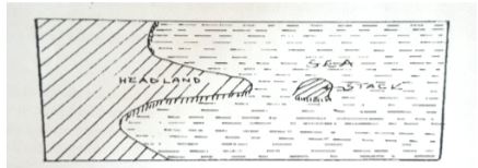
- Beaches
- Are accumulation of sand, pebbles and shingles between the low tides and the high tides upper limits of the wave action
- Concave in profile.
- Formed by wave deposition in a process called longshore drift.
- Waves bring materials to a gentle coast. The swash being greater than the backwash deposits shingles, sand and pebbles which over time accumulate to form beach.
- Stack
-
- Tourists attraction
- Fishing (Oceans)
- Transport and communication (sea transport)
- Limestone – building and construction.
- Tidal/wave energy can be harnessed from waves.
- Sand – building and construction.
- Harbours are built on headlands promoting trade and anchoring of ships.
- Forestry – mangrove trees which provides timber.
- Lagoons and mudflats can be irrigated for rice production.
-
-
-
- Define the word soil.
- Is the uppermost surface layer of unconsolidated material which lies on the surface of the earth and in which plant grow.
- Name two types of soil according to texture
- Loam
- Silt
- Clay
- Sand gravel
- Define the word soil.
- Explain how the following factors influence soil formation.
- Climate
- Rainfall provides the moisture required for rocks to weather chemically and eventually from soil.
- High temperature increases the rate of weathering and also accelerate the rate of bacterial activity which generates some organic matter in the soil.
- Climate influence the process of erosion by water wind and ice.
- Living organisms
- They assist in breaking down the rock through harrowing, ploughing and root penetration.
- They influence the chemical composition by removing organic acid solution/minerals.
- Climate
-
- Differentiate between soil profile and catena.
- Soil profile is vertical arrangement of different layers of soil from the surface to the bedrock while soil catena is the sequence of different soils down a slope on the surface of the land.
- Processes of development of soil profile.
- Podsolization
- Salinization
- Solodization
- Calcification
- Ferralization
- Differentiate between soil profile and catena.
- How the following human activities lead to soil erosion.
- Continuous ploughing
- It weakens the soil structure making it easy to the agent of erosion to carryit away.
- Cutting down trees
- Exposes the soil to the agents of soil erosion the ground is left bare.
- Continuous ploughing
- Explain two consequences of soil erosion.
- Soil water washed into water bodies contain agro-chemicals that are harmful to aquatic life.
- Water reservoirs get silted reducing their capacity and affecting their efficiency.
- When gullies are deepened to the water tables underground water is exposed.
- Productive topsoil is lost forever and only unproductive stony soil erosion is left.
-
-
- Intrusive volcanicity
- Where magma from the earth’s mantle fails to reach the earth surface, it become intruded within crystal rocks.
-
- Formation of dyke
- Magma cuts across the bedding planes of crystal rocks.
- The magma cools solidity within the cracks
- It remains vertically like a pillar.
- Other intrusive feature.
- Laccolith
- Lapolith
- Sill
- Phacolith
- Batholith
- Formation of dyke
- Characteristics of composite volcano
- It is cane shaped
- It is stratified/layer of lava
- Has conelets (parasitic)
- It has steep slopes
- Made from acidic lava
- Has a crater at the top.
-
- Objective
- To find out the volcanic features present
- To determine the PH of lava.
- To study effects of volcanicity of human activities
- Reasons for pre-visit
- Prepare a working schedule
- To familiarize with the route
- Enable estimate costs
- Seek permission
- Know which tools to carry.
- To draw up objectives
- Identify suitable data collection methods.
- Objective
- Explain three of volcanicity to human activities.
- Vacant rocks weather to form fertile soils for agriculture.
- Geysers can be harness to produce geothermal power
- Vacant features e.g. mountains are a tourist attraction hence forex.
- Igneous rocks are used for building construction.
- Crater lakes are sources of fish for human food.
- Volcanic mountainbring rainfall on windward side hence encourage agriculture.
- Volcanic eruption cause environmental pollution from release of dust, gas &sulphur dioxide.
- Volcanic mountain bring rain shadow effect on leeward side hence drought.
- Volcanic eruption causes loss of lives.
- Volcanic Mountainsare barrier to transport and communication.
- Intrusive volcanicity
Join our whatsapp group for latest updates
Tap Here to Download for 50/-
Get on WhatsApp for 50/-
Download Geography Paper 1 Questions and Answers - Samia Joint Mock Examination 2023.
Tap Here to Download for 50/-
Get on WhatsApp for 50/-
Why download?
- ✔ To read offline at any time.
- ✔ To Print at your convenience
- ✔ Share Easily with Friends / Students