
SECTION A
Answer all the questions in this section.
-
- How does a sea breeze occur? (2 mks)
- Use the map of Africa below to answer question b(i).
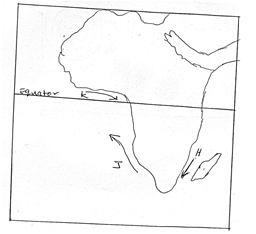
- Name the ocean current marked H, J and K. (2 mks)
- State two effects of a warm ocean current on the adjacent coastlands. (2 mks)
- Give two processes involved in each of the following types of weathering.
- Physical weathering (2mks)
- Chemical weathering (2 mks)
- The diagram below shows the composition of the solar system.
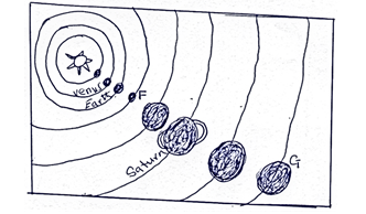
- Name two planets marked F and G. (2 mks)
- State three effects of the rotation of the earth on its axis. (3 mks)
-
- Give the specific dates of the year when the overhead position of the midday sun is at the following latitudes;
- Tropic of cancer (1 mk)
- Tropic of Capricorn (1 mk)
- Equator (2 mks)
- Give two characteristics of winter solstice. (2mks)
- Give the specific dates of the year when the overhead position of the midday sun is at the following latitudes;
- The table below represents rainfall and temperature figures for a town in Africa. Use it to answer the questions that follow.
Month
J
F
M
A
M
J
J
A
S
O
N
D
Temp (oc)
27
28
28
28
27
25
25
24
25
26
27
26
Rainfall (mm)
25
38
99
140
277
439
277
69
142
201
71
25
-
- Calculate the annual range of temperature for the town. (1 mk)
- Calculate the total annual rainfall for the town. (1mk)
- State two characteristics of the climate experienced in the town. (2 mks)
-
SECTION B
Answer question 6 and any other two questions in this section.
- Study the map of Taita Hills (sheet 189/4) and answer the following questions.
-
- Identify the type of map you have been provided with. (1 mk)
- Give three reasons for your answer in (a) (i) above. (3 mks)
-
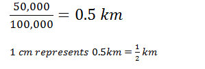
- Convert the scale of the map provided into a statements scale. (2 mks)
- Identify three man-made features found in the grid square 3926. (3mks)
-
- Identify three types of natural vegetation in the area covered by the map. (3 mks)
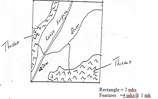
- Draw a rectangle of 8cm by 6cm to represent the area between easting 39 and 43 and between northing 26 and 29. In your rectangle show the following;
- Dam
- River
- Loose surface road
- Thicket (6 mks)
- Students from one of the schools in the area covered by the map were intending to carry out a field study on economic activities in the area.
- Giving evidences, state three economic activities they would identify. (3 mks)
- Give two methods of data collection they could use. (2 mks)
- Give two problems they are likely to face in their field study. (2 mks)
-
-
-
- Define the term weathering. (2 mks)
- Give five processes involved in physical weathering. (5 mks)
- Describe two ways in which plants cause weathering. (4 mks)
- Describe the formation of an exfoliation dome. (6 mks)
- Describe how the following factors influence weathering.
- Topography (4 mks)
- Temperature changes (4 mks)
-
-
- Name four types of faults. (4 mks)
- Identify three causes of faulting. (3 mks)
- Describe the formation of Rift Valley by compressional forces. (6 mks)
- State any three features resulting from faulting other than Rift Valley. (3 mks)
- Student from Igoji Secondary carried out a field study in a nearby faulted area.
- What were their sources of data. (3 mks)
- State three positive effects of faulting in the area they noted. (3 mks)
- Identify the problems they were likely to encounter in their study. (3 mks)
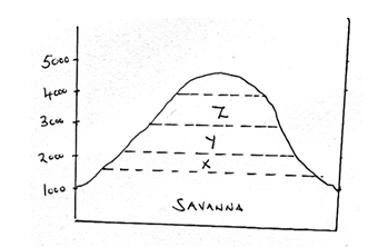
- The diagram below represents zones of natural vegetation on a mountain. Use it to answer questions in (a)
-
- Name the zones X, Y and Z. (3 mks)
- Describe the characteristics of savanna vegetation. (5 mks)
- State two reasons why the mountain top has no vegetation. (2 mks)
- Explain three factors that have led to decline of normal grassland in Kenya. (6 mks)
- You are planning to carry out a field study in your forest.
- Give three reasons why it is important to seek permission from the school. (3 mks)
- List three sources of information you are likely to use before the actual field study. (3mks)
- Identify four challenges you are likely to encounter during field study. (3 mks)
-
-
- What is karst scenery? (2 mks)
- The diagram below shows features in a karst scenery.
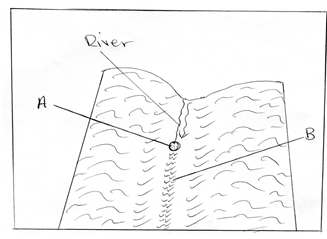
- Name the feature marked A and B. (2mks)
- Describe how the feature marked A is formed. (6 mks)
- Name three underground features of a karst scenery. (3 mks)
- Explain four conditions necessary for the development of karst scenery. (8 mks)
- Give four reasons as to why there are few settlements in a karst scenery. (4 mks)

MARKING SCHEME
SECTION A
-
- How does a sea breeze occur?
- During the day, the land heats faster than the sea
- The air over the land rises
- Cooler air from the sea blows towards the land to replace the rising air
- Cool air from the sea is called the sea breeze
(Any 2 x 1 = 2 mks)
-
- Name the ocean currents marked;
H – Mozambique/Agulhas (1 mk)
J – Benguela (1 mk)
K – Guinea (1 mk) - State two effects of a warm ocean current on the adjacent coastland.
- It warms up the adjacent land
- It increases the humidity of the adjacent land
- It may lead to rainfall on the adjacent land
(Any 2 x 1 = 2 mks)
- Name the ocean currents marked;
- How does a sea breeze occur?
- Give two processes involved in each of the following types of weathering.
- Physical weathering
- Pressure release/offloading/sheeting
- Block disintegration
- Exfoliation
- Frost action/frost shattering/free-thaw
- Crystal growth/crystallization
- Slaking/wetting/drying
- Granular disintegration
(Any 2 x 1 = 2 mks)
- Chemical weathering
- Hydrolysis
- Solution
- Oxidation
- Carbonation
- Hydration
(Any 2 x 1 = 2 mks)
- Physical weathering
-
- Name the planets marked F and G.
F – Mars (1 mk)
G – Neptune (1 mk) - Three effects of the rotation of the earth
- causes day and night
- causes rising and falling of ocean tides
- causes the deflection of ocean and air current
- causes a difference of one hour between longitudes 150 apart
- Name the planets marked F and G.
-
- Specific dates of the year when the overhead position of the midday sun is at;
- Tropic of cancer – 21st June (1 mk)
- Tropic of Capricorn – 22nd December (1 mk)
- Equator – 21st March and 23rd September (2 x 1 = 2 mks)
- Characteristics of winter solstice.
- Low temperature
- Longer night times than day times at latitudes beyond the equator
- The sun is overhead the tropic of Capricorn on 22nd December and its winter solstice in the northern hemisphere
- On 21st June, the sun is overhead the tropic of cancer and its winter solstice in southern hemisphere
(Any 2 x 1 = 2 mks)
- Specific dates of the year when the overhead position of the midday sun is at;
-
-
- Calculate the annual range of temperature for the town.
28o – 24oc = 4oc (1 mk) - Calculate the total annual rainfall for the town.
1803 mm (1 mk)
- Calculate the annual range of temperature for the town.
- State two characteristics of the climate experienced in the town.
- The town experiences high temperature throughout the year/24 – 28oc
- The annual range of temperature is small/4oc
- Rainfall throughout the year/no marked dry season
- The rainfall pattern has double maxima
- The wettest month is July/The direst months are December and January
- Rainfall is high/1803mm
- The hottest months are February to April/Coolest month is August
(Any 2 x 1 = 2 mks)
-
SECTION B
-
-
- Type of map.
Topographical map (1 mk) - Give three reasons for your answer in (a) (i) above.
- It has a medium scale
- Shows selected number of physical and human features and their position on the earth surface
- The human and physical features are shown by symbols
(3 x 1 = 3 mks)
- Type of map.
-
- Convert the scale of the map provided into a statement scale.
- Man-made features found on the grid square (3926).
- School
- Church
- All weather road; loose surface
(3 x 1 = 3 mks)
- Convert the scale of the map provided into a statement scale.
-
- Identify three natural vegetation.
- Scrub
- Woodlands
- Forest
- Thicket
(Any 3 x 1 = 3 mks)
- A rectangle of 8cm by 6cm to represent area between eastings 39 and 43 and between northings 26 and 29.
- Identify three natural vegetation.
-
- Give three economic activities identified.
- Transport – evidenced by road and railway
- Trade – presence of shop
- Crop/sisal farming – presence of sisal estates, farmers training centre
- Cattle keeping – presence of cattle dip
- Forestry – presence of forest/forest offices
(3 x 1 = 3 mks)
- Methods of data collection.
- Direct observation
- Taking photographs
- Interviewing a resource person
- Tape/video recording
- Administering questionnaire
(Any 2 x 1 = 2 mks)
- Problems they are likely to have faced.
- Fatigue because of steep slopes
- Swift flowing river may cause accident
- Adverse weather condition e.g. too hot
- Inadequate time/time constraint
(Any 2 x 1 = 2 mks)
- Give three economic activities identified.
-
-
-
- Define term weathering.
Weathering is disintegration of the rocks of the earth’s crust at or near the surface of the earth in situ. (2 mks) - Give five processes involved in physical weathering.
- Block disintegration/block separation
- Exfoliation
- Granular disintegration
- Frost action/alternating freezing and thawing
- Pressure release/unloading/sheeting
- Rain water/slaking/wetting and drying
- Crystals growth/crystallization
(Any 5 x 1 = 5 mks)
- Define term weathering.
- Describe ways in which plant cause weathering.
- Plant roots especially those of trees grow into the joints and cracks of rocks and as they grow the roots also become bigger and widens the joints and cracks and with time cause the block of rocks to separate
- Plant rot/decompose and in the process produce organic acid which react with some of the minerals within the rocks causing it to decay e.g algae
- Plants such as mosses and lichens grow on rocks and cause the are they occupy to be moist all the time and therefore create an enabling environment for chemical weathering to take place although lichens and mosses are not directly involved in weathering process
Any first two (2 x 2 = 4 mks)
- Describe the formation of exfoliation dome.
- During the day the heat of the sun cause the surface layers of the rocks to expand
- At night the low temperature results in cooling and contraction of outer layers
- This expansion and contraction occurs repeatedly and cause stress within the outer part of the rock
- Eventually the shell of the outer layer peels off from the main rock mass
- This leaves a rounded mass of rock known as exfoliation dome
- Examples are in Nyika plateau and Mudanda rocks in Tsavo East National Park
(Any 6 x 1 = 6 mks)
- Describe how the following factors influence weathering.
- Topography
On steep slopes the force of gravity is higher and thus the weathered materials are washed away quickly exposing the rock surface to more agent of weathering
On gentle slopes and flat areas force of gravity is lower and so the weathered materials remain in one place covering the rock beneath and this slows the rate at which weathering takes place (2 mks) - Temperature changes
During the day the heat of the sun causes the surface layers of the rocks to expand
At night the temperature results in cooling and contraction of outer layer
The expansion and contraction occurs repeatedly and causes stress within the outer part of the rock. Eventually outer shell peels off (2 mks)
- Topography
-
-
- Four types of faults.
- Normal faults
- Reverse faults
- Shear/tear faults
- Thrust fault
- Anticlinal fault
(Any 4 x 1 = 4 mks)
- Causes of faulting.
- Tension forces – causes rocks to stretch finally breaking them
- Compressional forces – causes rocks to fold and some sections of folded rocks may fracture
- Shear force – causes rocks to move along a line of weakness in opposite directions
(3 x 1 = 3 mks)
- Formation of Rift Valley by compressional forces.
- Layers of rocks are subjected to compressional forces
- Intense compressional forces causes lines of weakness to develop leading to formation of reverse faults.
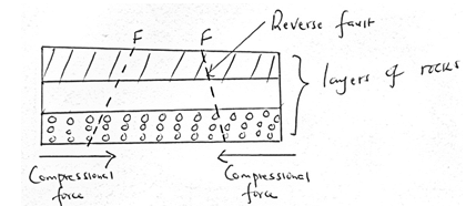
- Further compression pushes the entire side blocks over the middle block
- Middle block may remain static or sink slightly to form the floor of Rift Valley
- The overhanging parts eventually collapse and are eroded
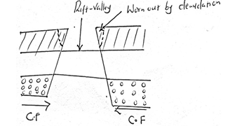
Diagram = 2 mks
Text = 4 mks
Total = 6 mks
- Features resulting from faulting other than Rift Valley.
- Escarpment/fault scarps
- Tilt blocks
- Block/horst mountain
(3 x 1 = 3 mks)
-
- Sources of data.
- Topographical map of the area
- Text books
- Photographs
- Recorded video clips
- Internet
(Any 3 x 1 = 3 mks)
- Positive effects of faulting.
- Lakes formed faulting provide water used for domestic purposes/irrigation/industry
- Scarp springs may be formed when fault scarp exposes underground water which are source of river providing water to use
- Faulting features e.g. Rift Valley may attract tourist hence earn foreign exchange
- Valuable minerals e.g. Diatomite may have been exposed due to faulting thus making mining easy
- Heavy rainfall is received on windward side of block mountains supporting agriculture
(Any 3 x 1 = 3 mks)
- Problems likely to be encountered.
- Inaccessibility of some area due to steep slopes
- Attack by wild animals
- Sudden change of weather e.g. may start raining
- Language barrier with local community
(3 x 1 = 3 mks)
- Sources of data.
- Four types of faults.
-
-
- Zones.
X – Rainforest
Y – Bamboo forest
Z – Health and moorland
(3 x 1 = 3 mks) - Description of savanna vegetation.
- Acacia trees are common/dominant species
- Grass dominant undergrowth in woodlands
- In wetter areas grass is tall and close together
- In drier areas grass is shorted and tufted
- Grass dominates the vegetation
- Trees are shorter and more scattered
- Trees are umbrella shaped
- Some trees are stunted and have scaly barks/drought resistant
- Some trees/shrubs are deep rooted
- Some trees e.g. baobab have thick back/trunks
- During dry season, grass wither away/trees shed their leaves/are deciduous
- During wet seasons, grass sprout and dormant seed germinate
(5 x 1 = 5 mks)
- Reason why Mount Kenya top has no vegetation.
- The temperature are too low to support plant growth
- There is no soil to support plant/bare rock
- Water is always in a frozen state
(3 x 1 = 3 mks)
- Zones.
- Factors that have led to decline of natural grassland in Kenya.
- Frequent outbreak of fires destroy grass retarding its generation
- Increased human population encroachment into grassland replacing them with settlement and cultivated land
- Pests such an armyworms/locust destroy the grass and the vegetation degenerates into semi-desert type
- Wild and domestic animals overgraze and cause stunted growth of grass
(6 x 1 = 6 mks)
-
- Reasons why it is important to seek permission.
- It is official requirement
- Enable administration arrange transport/lunch/meals
- Enable administration take care of disruption of the school programmes that will occur
- Enable administration provide entry fee if required
- Enable administration provide necessary tools
- Sources of information.
- Relevant textbooks
- Journals/magazines
- Internet/electronic media
- News papers
- Professionals/forest officers
(Any 3 x 1 = 3 mks)
- Challenges likely to encounter.
- Attack by wild animals/insect/snake bites
- Adverse weather conditions/too wet/too cold
- Thick/thorny vegetation/rugged terrain hinder movement within the forest
- Tiredness/fatigue due to long distances
- Inadequate time to collect data
- Getting lost/loss of direction to follow
- Uncooperative/absent respondent
- Injuries
(Any 3 x 1 = 3 mks)
- Reasons why it is important to seek permission.
-
-
- What is karst scenery?
Any rugged landscape whose surface rocks are limestone or dolomite.
(1 x 2 = 2 mks) -
- Name the features marked A and B.
A – Swallow-hole/sink hole (1 mk)
B – Dry valley(1 mk) - Describe how the features marked A is formed.
- It is called swallow-hole
- It is a vertical hole in the ground through which rain water or river water disappears into the ground
- The water widens and deepens the joints especially where such joints converge, leading to the development of a vertical hole
- The hole may slowly be deepened as water sinks through it
- When surface run-off or river disappears into this hole, it is then called a swallow-hole or sink hole
- The vertical shaft from the surface of the swallow hole down into the ground is called a ponor
(Any 6 x 1 = 6 mks)
- Name three underground features of a karst scenery.
- Stalagmite
- Stalactite
- Limestone pillars
- Underground caves and caverns
- Phreatic caves
(Any 3 x 1 = 3 mks)
- Name the features marked A and B.
- Explain four conditions necessary for the development of karst scenery.
- The surface rock and the rock beneath should be thick limestone, dolomite or chalk
- The rock should be hard and well-jointed
- The climate should be hot and humid to facilitate fast chemical weathering
- The water table in the limestone area should be deep below the surface to allow rocks above to form conspicuous features
- The rain should be moderate to high
(Any 4 x 2 = 8 mks)
- Give four reasons why there are few settlements in a karst landscape.
- The surface is rugged hindering construction of transport lines
- The surface of karst scenery has thin soils which is not suitable for agriculture
- The surface in karst scenery is rocky which discourages settlements
- Karst landscape experiences inadequate water supply both on the surface and underground
- The vegetation in most places in a karst scenery is poor and would not support livestock rearing
(Any 4 x 1 = 4 mks)
- What is karst scenery?
Join our whatsapp group for latest updates
Tap Here to Download for 50/-
Get on WhatsApp for 50/-
Download GEOGRAPHY PAPER 1 - KCSE 2019 STAREHE PRE MOCK EXAMINATION (WITH MARKING SCHEME).
Tap Here to Download for 50/-
Get on WhatsApp for 50/-
Why download?
- ✔ To read offline at any time.
- ✔ To Print at your convenience
- ✔ Share Easily with Friends / Students